CANNING STOCK ROUTE - Some Background Notes
Laurie McLean
Preface
During various periods of field duty with NatMap between 1969 and 1977, I spent some 330 days (about 11 months) in total under fairly basic camping conditions both supporting and undertaking mapping surveys in the Great Victoria, Gibson, Little Sandy and Great Sandy Desert regions of Western Australia. On numerous occasions I crossed over parts of the Canning Stock Route (both on the ground and in the air) and also obtained water for survey party use; mainly from Well 33 and also Well 35 (but only in 1969). Thirty years after last working in the area, I made a recreational vehicle trip along the stock route in 2007 to fill in the big bits I had previously missed and to become reacquainted with the area's uniqueness and beauty. Another NatMapper, Lawrie O'Connor accompanied me on that trip. Following the circulation to families and friends of travel notes and images taken during the trip, we received queries from people wanting to know more about both Canning and the route. This paper seeks to address such queries. However, the reader is warned that this is not an academic or definitive work. Rather, it is something I could put together conveniently for personal use to meet the above aim. Convenience was a key driver in that I had all cited references on hand or could access them from the internet. While I have drawn extensively from this reference material, I am conscious that other significant works, for example Ronele and Eric Gard's Canning Stock Route: A Travellers Guide have not been consulted; due to a mix of access difficulties and indolence. I have sought to resolve conflicts between references such as with dates by giving weight to the greatest detail (eg July 1959 is used from one source rather 1958 from another). In other cases I have simply relied on personal preference to resolve such matters. I trust the reader can gain some useful and interesting background from the following. As always responsibility for any errors or other shortcomings rests with the author.
What, Where, Why, When?
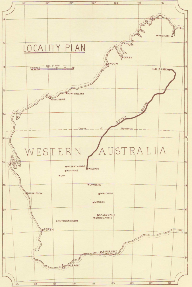
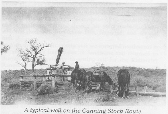
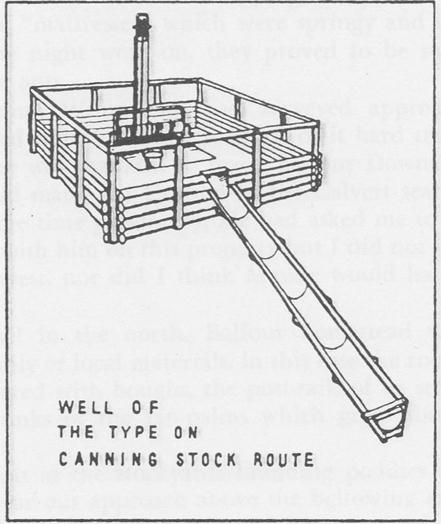
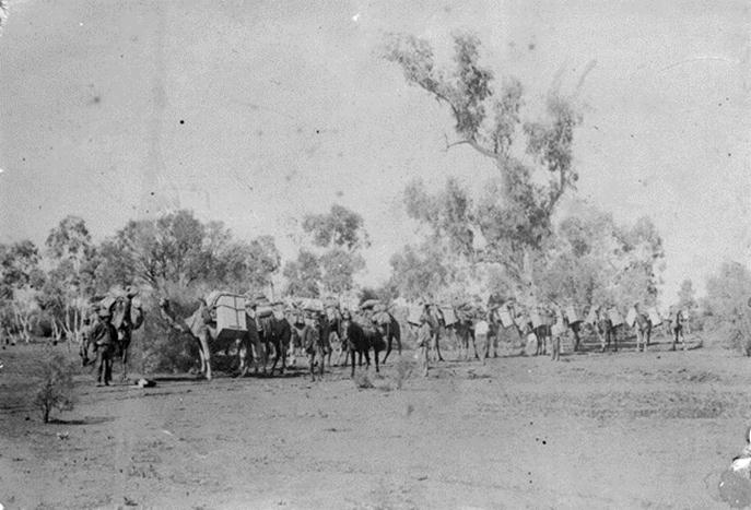
The Canning Stock Route is said to be one of the most isolated tracks on earth. It covers a distance of about 1,800 km across Western Australia's semi arid and desert country from Wiluna (in the Eastern Goldfields about 700 km north east of Perth) to Halls Creek in the East Kimberley (about 350 km south of the port of Wyndham and about 130 km west of the Northern Territory border), see Appendix A. It was constructed as the Wiluna - Kimberley Stock Route during 1908-10 by a party of 26 men under Surveyor AW Canning. (The route was formally renamed the Canning Stock Route in February 1967 but had previously been referred to by that name for many years.) During 1906-07, Canning had led a smaller exploration party to establish the feasibility of such a route. According to Canning's field notes, the original stock route had 68 native waters, bores and wells; these are listed in Appendix B and a typical well is depicted at Appendix C. Over time more wells were built and today the usual tourist route sees Well 51 Weriaddo (the northern most-well on Lake Gregory Aboriginal Land) as last of the Stock Route.
Cattle tick Boophilus micropolus (Canestrini) was introduced into Australia with the importation of cattle from what is now Indonesia in the early 1800s. It spread through the tropical north with devastating results on infected cattle that developed the fatal red water fever. Cattle in the West Kimberley and Pilbara were not affected and landholders in these areas objected to infected East Kimberley cattle being overlanded through their country. Shipping cattle to southern markets from Wyndham was uneconomic so East Kimberley pastoralists began lobbying the state government for development of a stock route through the desert from Sturt Creek to Wiluna so they could supply the Eastern Goldfields. The pastoralists argued (correctly as it turned out) that cattle tick would not survive in the dry desert environment and so there would be no need to have the cattle dipped (for tick control) before droving them south.
Wiluna
Wiluna is a small regional service centre for the surrounding pastoral country and mining operations. Prospectors Woodley, Wotten and Lennon discovered gold near Wiluna on 17 March 1896. Originally called Weeloona, the spelling was changed when the town was gazetted in 1897. Origin of the name is uncertain but is thought to be a native word for place of the wind or for the call of the stone curlew, a local native bird. Gold mining saw the town's population peak at around 9,000 people in the mid 1930s. At this time there was a regular train service to Perth, an air service, 4 hotels and numerous other facilities. World War 2 had a severe impact on gold mining and the town declined, particularly when underground mining ceased. By 1953, the population was 350 people and by 1963 it was only 90 people. More recently the population has stabilised at about 300 which includes a high proportion of Aboriginal people.
Halls Creek
Today, Halls Creek is a thriving regional and tourist service centre on the Great Northern Highway (National Route 1) with a population of about 1,300 people including a high proportion of Aboriginal people. It is named after prospector Charlie Hall who with Jack Slattery made the first discovery of gold in Western Australia in 1885. (This discovery was near the old townsite about 15 km east of the town's present location.) A short but intense gold rush followed Hall and Slattery's discovery and a town quickly grew to 2,000 people. However, gold finds soon dwindled and after the discovery of gold at Southern Cross in 1888, Halls Creek was pretty much a ghost town. Interesting remains of the old town still exist but with the building of an airfield and subsequent re-routing of the highway, the town was progressively shifted to its present site between 1948 and 1954.
Use of the Stock Route
There were some 35 cattle drives down the Canning; of which 29 were of Billiluna cattle. The first cattle to head down the stock route was a mob of 150 bullocks that left Flora Valley Station (south of Halls Creek) under drover James Campbell Thomson (aged 38) with Christopher Frederick George Shoesmith (aged 32) and a part Aboriginal named Chinaman (aged 25 years). (The party had included Fred Terone but he returned to Halls Creek after a few weeks due to conjunctivitis.) Tragically the other 3 were speared to death by natives on the night of 25-26 April 1911 at Well 37. The tragedy was discovered by drover Tom Cole (of Wyndham) who was bringing down the next mob. Cole found Thomson's horse partly eaten at Well 45 and by the time he reached Well 38 the number of wandering cattle alerted him that something was amiss. Cole camped his cattle and rode ahead to discover the bodies on 30 June 1911.
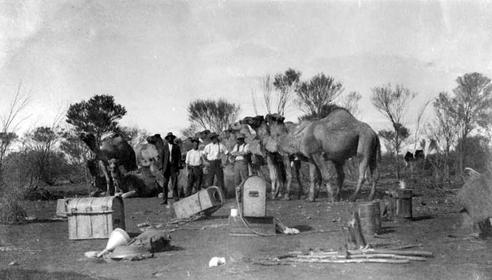
For some years after Tom Cole's trip the stock route was not used, apparently because of its remoteness and fear of native hostility. The next party known to traverse the route was magnetician Edward Kidson (1882-1939, an English born New Zealander) who left Leonora (300 km south of Wiluna) on 20 May 1914 and arrived at Flora Valley Station on 16 August. As the chief observer in Australia for the Carnegie Institution of Washington Department of Terrestrial Magnetism (CIW/DTM), that was undertaking a world wide magnetic survey project, Kidson made observations for magnetic inclination, declination and horizontal intensity at 48 accurately positioned sites between Leonora and Wyndham. Kidson was accompanied by Messrs Clark, Cronin and Ryan as well as Nipper an exceptional Aboriginal tracker who had already made 3 journeys along the stock route with Canning. They used 12 camels.
At Wiluna, Kidson was advised to be careful of desert Aborigines which were said to be treacherous and unreliable. A number of times he warned off small groups of Aborigines that were following his party. At Well 36 he made a protective shelter with his stores and equipment and kept the camels tied rather than hobbled. His dog Nellie growled throughout the night for unknown reason. After reaching Halls Creek, Kidson travelled on to Wyndham and left there by sea. His party returned along the stock route; arriving back at Leonora on 23 November 1914. (See Appendix D for images of this expedition.)
In 1922, the Locke Oil Expedition travelled the Stock Route from Leonora to Halls Creek; it was led by geologist LA Jones and included as his assistant Horace Patrick Buckley (then a university student). The party comprised 11 men with a number of camels, see Appendix E. One of the expedition's camel drivers JV (Jock) McLernon was killed by a native nulla-nulla as he slept about 30 miles east of Well 37. Two other expeditioners fought off the natives and brought McLernon's body to the well for burial. (In 2007, the old metal plaque on this grave was marked W McLennon, apparently in error.)
Tom Cole had criticised the stock route for stages being too long and feed being poor. He said an advance party had to travel ahead in case 2 successive wells were unfit for use and the wells provided sufficient water only for mobs of 300 cattle with a week being needed for wells to replenish. William Snell a land owner and well known bushman said the route should be positioned 100 km further east where there was more feed. Following pressure from station owners, the government agreed to re-equip the stock route in 1928. It initially gave the job to Snell who commenced from a base at Weld Springs in February 1929 and by October his party was at Well 35, having made 5 new wells and reconditioned 33 others. With the northern wet season approaching and steel supplies exhausted, Snell decided to return to Wiluna where he sadly found his only son had died on 15 September. It was perhaps due to Snell's personal situation, that the government asked Canning to come out of retirement to complete the task, which he did between March 1930 and August 1931.
During the 1930s, use of the stock route increased and for the next 20 years at least one mob a year was brought down. George Lanagan of Billiluna made four trips down the stock route, his last full trip being in 1940. On this last trip, Eileen Lanagan (George's wife) became the only known white woman to come down the route with a mob of cattle. Each day she would ride ahead of the cattle and prepare the team's camp and burn any poison bush (Gastrolobium grandiflorum) before the cattle could graze on it. (On 7 March 1940, Lanagan marked the graves at Well 37.) Jerry Pedro a part Aboriginal who retired near Broome, travelled down 3 times with Wally Dowling and Mal Brown (Mal made a total 11 trips up or down the route). Jerry and Wally also took up a mob of horses they trapped east of Laverton. Jerry said progress on the track depended on the season. After a good wet there would be plenty of feed and water in the claypans; his last trip took 14 weeks. Between 1942 and 1944, fears of a Japanese invasion led to the stock route being prepared for the possible mass exodus of people and livestock from the Kimberley. The Kalgoorlie Water Supply reconditioned a number of the wells. In 1955, drover Jack Gordon brought down a mob of 500 cattle but lost many due to problems with drawing water at Well 20. As time progressed, drovers adopted new methods to make working the stock route easier. In latter years, portable petrol powered pumps and rubber hoses were used to draw water from the wells rather than the camel, whip pole and steel bucket. Towards the end of droving, the stock route could only be used by Billiluna Station due to concern of spreading pleuro-pneumonia to southern cattle. The last mob brought down the stock route left Billiluna in 1959 under Len Brown. He brought the mob to Well 22 where George Lanagan (then living at Meekatharra) took over to bring the mob to Wiluna, in July 1959.
Vehicles and others on the Stock Route
The source literature gives some slightly conflicting accounts on the history of droving and vehicle travel on the stock route. However, it appears that one of the first vehicle expeditions was that of Michael Terry. He completed a number of remarkable journeys in various parts of Australia in the 1920s and 30s. In 1925 his expedition travelled from Billiluna to the Southesk Tablelands (that are between Wells 47 and 48). In the 1930s, George Herbert from Wiluna drove as far as Well 10 and soon after surveyor H Payne also travelled on some of the southern section. In 1942, a convoy of 5 army vehicles under Captain E Russell attempted to travel the whole route from Wiluna. However, owing to a very wet season and boggy conditions near Lake White they had to turn back when about 16 km north of Well 11. Also in 1942, the Kalgoorlie Water Supply got a truck as far north as No 17 Water Killagurra when reconditioning wells. In 1954, George Lanagan led a party of 3 four wheel drive vehicles from Wiluna over station tracks to Talawanna homestead and then overland across the desert to Well 22.
In June 1959, Division of National Mapping supervising surveyor HA (Bill) Johnson did a geodetic traverse reconnaissance in a Landrover from Wiluna to Well 14. Johnson said this was to prove if the stock route could be traversed without the use of camels or packhorses and had followed his discussion with George Lanagan who believed it was possible to travel the whole stock route in a carefully driven normal four wheel drive. Starting in September 1962, Johnson travelled the stock route alone in an AB120 International from Well 35 to Billiluna and then on to Halls Creek; a vehicle distance of 782 km. During this trip, sites for 23 survey stations were selected to give line of site for the survey traverse between Well 35 and Halls Creek. These survey stations were established and observed during May - August 1964; commencing at Halls Creek. The 1964 traverse party was led by NatMap's RA (Reg) Ford, senior technical officer.
To assist with access for the vehicles of his 12 man party, Ford arranged for a contractor to grade a track generally near the stock route between (then) old Billiluna homestead and Well 45; a distance of about 250 km. After Well 45, Ford continued scraping an access track using his party's 2 Bombardier light tracked vehicles powered by 6 cylinder Chrysler engines. However, the Bombardiers proved unsuitable in the sandhills and the engines eventually failed near Well 41 after a further 140 km of track were made (but still about 180 km north of the Well 35 objective). As the track Fords' party made was to meet the access needs of the survey, it didn't stick strictly to Canning's route. The Woomera rocket range and NatMap's survey needs resulted in several tracks being made across the stock route in the early 1960s. Many tracks were made in the western deserts by the Weapons Research Establishment's Len Beadell. Some were solely for NatMap's geodetic survey requirements. Beadell's track into Well 35 from the east followed the 1961 wheel tracks of NatMap's surveyor OJ Bobroff from Jupiter Well and Beadell's track from Well 35 to the Calawa Creek telegraph line near the west coast followed Reg Ford's 1962 wheel tracks as well as some 200 km of track Ford's party scraped with rudimentary equipment on the western end of this line. Two of Beadell's other tracks followed routes selected and plotted by NatMap, namely: the Young Range to Well 35 track and Windy Corner to Talawanna homestead track (which crossed the stock route near Wells 23 and 24). NatMap's survey parties visited and sometimes drew water from Canning wells during the late 1960s to mid 1970s including Wells 33 and 35 in 1969, Well 24 in 1970, Wells 24 and 33 in 1972 and Well 33 in 1975 and 1977.
According to a plaque at the site, on 21 November 1965, oil explorer and producer Western Australian Petroleum Pty Ltd spudded their Kidson No 1 well in the Canning Basin about 50 km south east of Canning's Well 33. The WAPET well was abandoned on 20 July 1966 at a depth of 14,539 feet (4,431 m). This oil search well was a significant undertaking and included the construction of a major access road for the heavy drilling and ancillary equipment. Referred to variously as the WAPET Sahara track, the WAPET road or the Kidson track, the road covered a distance of about 660 km. It ran from near the Wallal Downs homestead turnoff on the Great Northern Highway to Swindell's Field airstrip (about 340 km south east of the Wallal Downs turnoff). It then ran about 300 km further to the Kidson drill site and beyond for about 20 km to an associated airstrip and its termination at Beadell's Young Range to Well 35 access track (later referred to as the Gary Highway). Unlike Beadell's graded scrapes, the WAPET access was a made road with long sandy flats gravelled over and the (relatively few) sandhills it crossed cut into, clayed, gravelled and side fenced to limit sand drift. However, like Beadell's tracks, being unmaintained, it suffered the wash away and gutter forming ravages of the wet seasons and the corrugating effects of vehicle use as time progressed. As well as WAPET, this road was used extensively by NatMap (during the late 1960s and 1970s) and by numerous other travellers.
In 1964, Swindell's Field was used as a supply depot and base for native patrol officers involved in the clear out of the Martu people from part of their traditional lands affected by a 160 by 145 km dump area in which Blue Streak (or other) rockets from the Woomera range were intended to land. (In July 1965, NatMap's technical assistant, Bob Goldsworthy together with field assistants K Snell and W Sutherland recovered over 60 pieces of a rocket that came down to the north west of Well 35; the largest piece was 17' by 2'.) In a November 1964 report on a Blue Streak clear out patrol between Wells 30 and 40, native patrol officer Robert Macauley noted: The wells on the Canning are generally in good condition with the quality of the water good and safe without boiling. Supply was plentiful in all cases. The timbering at most wells has lasted surprisingly although there are signs of decay appearing. Most wells still retained buckets and windlasses, and in some cases, covers over the wells. Troughs are scattered around each well, and at Well 31 had been used as a wind-break by Aborigines in earlier days. The stock route is not readily visible from the air or even the ground at first. There are no cattle or human tracks visible. However, the Canning Basin itself becomes apparent on close scrutiny. For most of its course between Wells 30 and 40, it is marked by a conspicuous belt of numerous closely jumbled sandhills on its western side, an open spinifex plain about two miles wide to the eastern side, and a continuous eroded gravelly plateau with jutting low headlands about three miles to the east. The stock route follows the main basin which is a slight depression with a good coverage of low acacias. Wells 31, 32 and 33 are found among tea-trees, but Wells 34 - 40 are among the sandhills just to the west of the actual basin.
On 10 July 1968, Dave Chudleigh (a surveyor with the Australian Survey Office, Canberra) together with Rus Wenholz (from Queanbeyan) and Noel Kealley (from Perth) drove the whole length of the stock route. Travelling in 2 short wheelbase Landrovers on a private excursion during annual leave, this party faithfully followed Canning's route and reached Halls Creek 34 days later having travelled 2,575 km. They had fuel supplies positioned at Wells 35 and 48 and had a food resupply at Well 33. Theirs' was the first recorded vehicle traverse of the stock route.
During and since the 1970s, the stock route has seen increasing recreational use by private users and commercial operators in four wheel drive vehicles. Four wheel drive clubs, similar voluntary organisations and groups of interested individuals have done much to provide for travellers by improving and marking the track and reconditioning some of the wells. Chemical toilet facilities have been provided at Well 6 and Durba Springs, two of the most heavily used camping areas. Fuel and food supplies can be obtained from the Kunawarritji Aboriginal Community that has established extensive facilities near Well 33. (The settlement at Kunawarritji dates from the 1980s when members of the Martu people formed several outstation settlements in the western desert to protect their homelands and way of life after being encouraged, or perhaps more correctly, cleared out, as were other desert Aboriginal people in to missions on the edges of the desert in the 1950s and 60s when their lands were used for the rocket range.) Also, arrangements can be made with the Capricorn Roadhouse (on the Great Northern Highway south of the mining town of Newman) for fuel to be dumped at Well 23. Following an unsuccessful attempt in 1974, Murray Rankin and Rex Shaw walked the stock route from Wiluna to Billiluna in 1976. In 1991, Georgia Bore was established between Wells 22 and 23 by CRA Exploration Pty Limited providing good water for benefit of travellers. In 2007, Heidi Douglas travelled down the stock route with 2 camels and a horse. In July 2004, a solo transcontinental camel expedition camped at Well 49. Tourist use of the stock route is now so extensive that it is putting some pressure on this fragile country; just one example being absence of dead timber at the most convenient or picturesque camping sites due to camp fire use.
European Exploration
Between Wells 15 and 40, the stock route runs through traditional Martu lands. The nomadic Martu Aboriginal people are believed to have occupied the western desert region for around 26,000 years and few had contact with Europeans until the twentieth century. In the early 1960s, one tribal group in the McKay Range area (west of Well 23) had its first direct European contact when Len Beadell was surveying for the Talawanna track. For others, the clear out era saw their first contacts. In 1977, an old nomadic couple, Warri and Yatunga, were found living traditionally outside present day Martu lands about 150 km south-east of Lake Disappointment.
Apart from Canning, a number of European explorers travelled on, near, or across parts of the stock route. The first was August Charles Gregory who left Brisbane by ship in 1855, travelled up the Victoria River and established a depot at Timber Creek, now in the Northern Territory. From there he explored south in to the Tanami Desert and then to the west where in February 1856 he discovered and named Sturt Creek which he followed for some 300 miles until it ran into a dry salt lake (later known as Gregory's Salt Sea but is now known as Lake Gregory). Perceiving he had entered what he termed the Great Australian Desert, on 9 March 1856 Gregory turned north east to retreat to the Victoria River and later travelled overland to the Queensland coast. (Canning's Well 51 Weriaddo lies on the south western corner of Lake Gregory and his original stock route followed Sturt Creek much of the way from there to old Halls Creek. With its old homestead situated on Sturt Creek at the northern end of Lake Gregory, Billiluna Station of some 160,000 hectares was first taken up by Joseph Condren in 1920. In early September 1922, Condren and the station's cook Timothy O'Sullivan were shot dead by an Aboriginal known as Banjo.)
Peter Egerton Warburton's party crossed the northern part of the stock route in 1873 at Mount Romilly and passed near Well 47 on his way from the Overland Telegraph line at Alice Springs enroute to Joanna Spring then to the Oakover River and eventually Roebourne. In 1874, John Forrest in company with his brother, Alexander and others, succeeded in finding an overland route from Perth to South Australia, completing the journey in five months. He found and named waters on the southern section of the stock route that Canning later used namely: Windich Springs (No 4A Water), Pierre Spring (Well 6) and Weld Springs (Well 9). Between 1872 and 1876 Ernest Giles led 5 expeditions into Australia's unknown western interior, the last 2 on camels. On his final crossing from the Murchison River to the Overland Telegraph line in 1876, his party crossed the stock route between the Calvert Range and Trainor Hills to the north of Well 15.
As leader of the so called Calvert Scientific Exploring Expedition during 1896-97, Lawrence Wells travelled to the east of the stock route with a reconnaissance party in 1896 naming, amongst other features, the Runton Range, Calvert Range and Trainor Hills (near Wells 15 and 16) and several weeks later with his main party he crossed the stock route between Wells 29 and 30, naming Thring Rock, King Hill and Lake Auld. Soon after his cousin Charles Wells with George Jones left the main party for further reconnaissance and perished when they were unable to find water.
The Hon David Carnegie's expedition from the southern goldfields to Halls Creek in 1896 touched on the northern part of the stock route around Wells 48 and 49; he named many features including the Southesk Tablelands, Godfrey's Tank, Breaden Pool, Twin Heads and Mount Ernest. Frank Hann, an outstanding explorer and bushman who endured indifferent luck and tough times through much of his life, discovered and named Lake Disappointment and the Mackay and McFadden Ranges during his exploration of the Pilbara east of Nullagine in 1897; his route came near Wells 19 and 20.
Readers interested in gaining further knowledge of these explorers can read extracts from their journals at Appendix F.
Canning - the Man
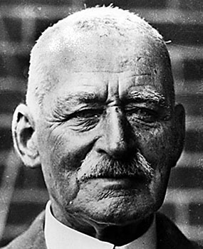
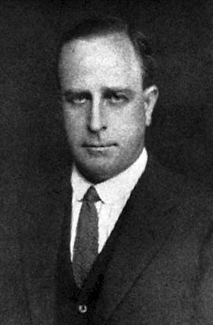
(Alfred Wernam Canning : Courtesy Eastern Goldfields Historical Society)
Alfred Wernam Canning was born on 21 February 1860 at Campbellfield Victoria, son of William Canning, farmer and his wife Lucy (née Mason). Educated at Carlton College Melbourne, he entered the survey branch of the New South Wales Lands Department as a cadet. In January 1882 he was appointed licensed surveyor under the Real Property Act. He served at Bega (1883-86), Cooma (1887-89) and as a mining surveyor at Bathurst (1890-92). On 17 April 1884, he married Edith Maude Butcher in the Mary Immaculate Roman Catholic Church at Waverley, Sydney. They had one son who died in 1923.
Canning joined the Western Australian Lands Department in 1893. In routine surveying over the next 8 years, he proved himself a first-class bushman and reliable surveyor, including leading a survey along the coast from Albany to Eucla. About the turn of the century rabbits were invading Western Australia from the east. Following a Royal Commission, in 1901 Canning was instructed to survey a route for a rabbit-proof fence. This took him from Starvation Boat Harbour about 125 km west of Esperance on the south coast to Cape Keraudren, 130 km north east of Port Hedland, over 1,800 km. Said at the time to be the longest single survey in the world, it took him three years to complete. Construction of No 1 Rabbit Proof Fence along his line was completed in 1907. Two other shorter fences were subsequently constructed and parts of the original and later fences are still maintained today. During this survey, owing to the loss of 2 of his camels, Canning walked 210 miles in 5 days, including one waterless stretch of 80 miles.
In 1906, the State government planned a stock route to bring cattle from the East Kimberley to feed the Eastern Goldfields. David Carnegie had explored further east in 1897 and concluded it was absolutely impracticable. Canning proved otherwise. With 8 men, 23 camels and 2 horses, he left Day Dawn (near Cue about 550 km north east of Perth) in May 1906, aiming to find water sufficient for stock every 24 km of the 1,800 km route. He reached Halls Creek in October 1906 with the task successfully accomplished. In January 1907, after resting and re-equipping, the party returned to Perth via the same route. Tragically, about 5:30pm on 6 April 1907 near what is now Well 40 one member of his party, Michael Tobin, was fatally speared by a hostile native. After his return, Canning faced publication of charges by E Blake, the expedition cook, that Aboriginals had been ill treated. A royal commission exonerated Canning in January 1908 although he had admitted chaining Aboriginals at night albeit with prior permission of the Commissioner of Police. Blake made his accusations (which he later withdrew) only after being informed he was not selected for Canning's second expedition.
Canning's optimistic survey and feasibility report to the government was accepted and he organized a second, larger expedition (of 26 men, 62 camels, 2 horses, 2 waggons, over 100 tons of equipment and 400 goats for milk and meat) to construct the necessary wells along the route. In temperatures varying from below freezing at night to extreme heat during the day, Canning led his party with mild courtesy and resolute example. Calculating distances principally by his own unvarying pace, he would walk for hours, regardless of the weather. Much of the country included desert sand-ridges 15-18m high which had to be crossed every km or so. Leaving completion of some of the southern wells for the return journey, he finished this Herculean task in Wiluna in March 1910. His telegram advising of this considerable feat was typically understated: Work Completed Canning. He addressed the Royal Geographical Society in London later that year on the benefits ...of the new highway and waterway between northern and southern Australia ...we have made (reported in the London Daily Express) and on the agricultural and pastoral potential of the north of Western Australia.
In July 1912, Canning became district surveyor for Perth. In 1915, he was a member of the Pastoral Appraisement Board. During 1917-22 he was surveyor for the northern district. He resigned from public service in 1923 and went into partnership with HS King as a contracting surveyor. In 1930, at the invitation of the government, Canning (age 70 years) led a new expedition to complete reconditioning of the northern wells to reopen the stock route which had been virtually abandoned. Subordinates remembered how he walked the whole distance twice: leading the men to a well, then while the men were cleaning it, walking on 24 km ahead to locate the next one. After this tremendous feat, he lived in retirement until he died of progressive muscular atrophy at his home in Perth on 22 May 1936. He was buried in Karrakatta cemetery with Church of England rites and left an estate that was valued for probate at £A1012.
Source, drawn from: Slee, John: Canning, Alfred Wernam (1860 - 1936), Australian Dictionary of Biography, Volume 7, Melbourne University Press, 1979, pp 557-558. (Obtained from web search on Alfred Wernam Canning, April 2009.)
References
1. Blackburn, Geoff: Calvert's Golden West, Hesperian Press, Victoria Park, 1997.
2. Bohemia, Jack and McGregor, Bill: Nyibayarri: Kimberley Tracker, Aboriginal Studies Press, Canberra, 1995
3. Burbidge, Andrew A: et al, Aboriginal Knowledge of the Mammals of the Central Desert of Australia, in Australian Wildlife Resources, 1988, 15, pp 9-39. (Obtained from web search on Lanagan, April 2009 that yielded: http://www.publish.csiro.au/?act=view_file&file_id=WR9880009.pdf .)
4. Canning, AW: Plan of Wiluna-Kimberley Stock Route Exploration also shewing positions of wells constructed 1908-9-10, Memento map for the 150th Anniversary Celebrations of Western Australia, Department of Mines, Perth, 1978.
5. Carnegie, David W: Spinifex and Sand: A Narrative of Five Years Pioneering and Exploration in Western Australia, C Arthur Pearson Limited, London, 1898. (Downloaded during April- May 2009 from Journals of Australian Land and Sea Explorers and Discoverers; Project Gutenberg Australia e-books accessed at http://gutenberg.net.au/explorers-journals.html .)
6. Cannon, Michael: The Exploration of Australia, Readers Digest, Sydney, 1987.
7. Chudleigh, DC: Retracing the Canning Stock Route and Other Early Explorers' Routes in Central Western Australia, The Australian Surveyor, December 1969, pp 555-563.
8. Davenport, Sue; Johnson, Peter; and Yowali: Cleared Out: First Contact in the Western Desert, Aboriginal Studies Press, Canberra, 2005.
9. Deasey, William Denison: Warburton, Peter Egerton (1813 - 1889), Australian Dictionary of Biography, National Centre for Biography, Australian National University. (Obtained from web search on Peter Egerton Warburton, May 2009 which yielded: http://adb.anu.edu.au/biography/warburton-peter-egerton-4798/text7993 .)
10. Deckert, John: The Canning Stock Route 3rd Edition, Westprint Heritage Maps, Nhill, 2004.
11. Donaldson, Mike and Elliot Ian, Eds, Do Not Yield To Despair: Frank Hugh Hann's Exploration Diaries in the Arid Centre of Australia, Hesperian Press, Victoria Park, 1998.
12. Ford, RA: The Division of National Mapping's Part in the Geodetic Survey of Australia, The Australian Surveyor, June, September & December 1979, Vol 29, Nos 6-8.
13. Forrest, John: Explorations in Australia, Sampson Low, Marston, Low, & Searle, London, 1875. (Downloaded during April- May 2009 from Journals of Australian Land and Sea Explorers and Discoverers; Project Gutenberg Australia e-books accessed at http://gutenberg.net.au/explorers-journals.html .)
14. Giles, Ernest: Australia Twice Traversed: The Romance Of Exploration, Sampson Low, Marston, Searle & Rivington Limited, London, 1889. (Downloaded during April- May 2009 from Journals of Australian Land and Sea Explorers and Discoverers; Project Gutenberg Australia e-books accessed at http://gutenberg.net.au/explorers-journals.html .)
15. Hema Maps Pty Ltd: Australia's Great Desert Tracks (map series), North West Sheet, 4th Edition, 2007, Eight Mile Plains.
16. Hewitt, David: A Brief History of the Canning Stock Route, 29pp booklet prepared for Canning Stock Route Aerial Tours, East Victoria Park, (revised) 1980. Copy provided by the late David Roy Hocking circa 1984.
17. Gregory, Augustus Charles and Gregory, Francis Thomas: Journals of Australian Explorations, James C Beal, Government Printer, Brisbane, 1884. (Downloaded during April- May 2009 from Journals of Australian Land and Sea Explorers and Discoverers; Project Gutenberg Australia e-books accessed at http://gutenberg.net.au/explorers-journals.html .)
18. Johnson, HA: Geodetic Surveys through the Australian Sandridges, The Australian Surveyor, September 1964, pp157-184.
19. Kennedy, Brian and Barbara: Australian Place Names, Hodder and Stoughton, 1992, Sydney.
20. Macauley, Robert: Report on Blue Streak F2 Patrol October 1964, Patrol Report, 13 November 1964, National Archives of Australia, Canberra Office, A6456 R136/008. (Downloaded on 11 May 2009 from: http://mc2.vicnet.net.au/home/pmackett/RMacaulay_13_11_1964.html .)
21. Morrison, Doug: Geophysical History: 90 years ago some pioneering field trips (Part 1) A geophysicist and some camels, Preview, April 2005, No115 pp 16-19, Australian Society of Exploration Geophysicists, Perth. (Obtained from web search, April 2009 on Kidson which yielded: http://www.publish.csiro.au/?act=view_file&file_id=PVv2005n115.pdf .)
22. Readers Digest Services Pty Limited (Eds): Readers Digest Atlas of Australia, Readers Digest Services Pty Limited, Sydney, 1977, (in which the maps were sourced from the Division of National Mapping's 1:1million scale International Map of the World series).
23. Shire of Halls Creek: website, accessed April 2009.
24. Shire of Wiluna: website, accessed April 2009.
25. Slee, John: Canning, Alfred Wernam (1860 - 1936), Australian Dictionary of Biography, National Centre for Biography, Australian National University. (Obtained from web search on Alfred Wernam Canning, April 2009, which yielded: http://adb.anu.edu.au/biography/canning-alfred-werman-5499/text9355 .)
26. Smith, Eleanor: The Beckoning West: the story of H. S. Trotman and the Canning Stock Route, Hesperian Press, Victoria Park, 1998 (first published 1966).
27. Steele, Christopher Wells, Lawrence Allen (1860 - 1938), Australian Dictionary of Biography, National Centre for Biography, Australian National University. (Obtained by web search May 2009 on http://adb.anu.edu.au/biography/wells-lawrence-allen-9043/text15931 .)
28. Warburton, Peter Egerton: Journey Across The Western Interior Of Australia, Sampson Low, Marston, Low, & Searle, London, 1875. Facsimile edition, Hesperian Press, Victoria Park, 1981.
29. Waterson, DB: Gregory, Sir Augustus Charles (1819 - 1905), Australian Dictionary of Biography, National Centre for Biography, Australian National University. (Obtained from web search on AC Gregory in April 2009 that yielded: http://adb.anu.edu.au/biography/gregory-sir-augustus-charles-3663/text5717 .)
30. Wells, LA: Journal of the Calvert Scientific Exploring Expedition, 1896-97, Wm Alfred Watson, Government Printer, Perth, 1902. Facsimile edition, Hesperian Press, Victoria Park, 1993.
31. Whittell, H M: Herman Franz Otto Lipfert, The Emu, Vol. XL, pp118-119, August 1940. (Obtained from web search on Canning in April 2009 that yielded:
www.publish.csiro.au/?act=view_file&file_id=MU940118.pdf .)
Prepared during April & May 2009.
Appendix A
Source: Canning, A W, Plan of Wiluna-Kimberley Stock Route Exploration also shewing positions of wells constructed 1908-9-10, Memento map for the 150th Anniversary Celebrations of Western Australia, Department of Mines, Perth, 1978.
Appendix B
CANNING STOCK ROUTE WATERS
LEAVING WILUNA
|
No |
Name |
No |
Name |
|
1 |
Well |
35 |
Minjoo, N slightly E is Bungabinni native well. |
|
2 |
Nigarra Well |
36 |
Wanda. NE of Wanda is Ural native well (n w). |
|
3 |
Well |
37 |
Libral |
|
4 |
North Pool |
38 |
Wardabunni |
|
5 |
Bore |
39 |
Murguga |
|
6 |
Lake Nabberu |
40 |
Waddawalla |
|
7 |
Soak |
41 |
Tiru. To the NE is Gunowarba native well. |
|
8 |
Windich Springs |
42 |
Guli. East and slightly north is Warrabuda n w |
|
9 |
Pierre Spring |
43 |
Billowaggi |
|
10 |
Bore |
44 |
Well |
|
11 |
Weld Spring |
45 |
Well |
|
12 |
Goodwin Soak |
46 |
Kuduarra |
|
13 |
Soak |
47 |
Well |
|
14 |
Native Well |
48 |
Well. Between 47 and 48 a bore was sunk. |
|
15 |
Well |
49 |
Well |
|
16 |
Bore |
50 |
Well |
|
17 |
Killagurra. Slightly to the NE is Durba Springs |
51 |
Weriaddo |
|
18 |
Well. To the NE is Onegunyah Rockhole |
52 |
Guda Soak to NE of Weriaddo, Gregory's Salt Sea on the E. |
|
19 |
Kunanaggi, with Lake Disappointment on the E |
53 |
Billiluna Pool |
|
20 |
Well |
54 |
Kura Soak. Permanent water, slightly brackish. |
|
21 |
Well due W is Gunanya Spring in McKay Range. |
55 |
Wolfe Creek |
|
22 |
Well. Sunk on a rockhole. |
56 |
Ima Ima Pool |
|
23 |
Well, with native water to the E |
57 |
Wowaljarrow Pool |
|
24 |
Karrara Soak |
58 |
Waterhole |
|
25 |
Well |
59 |
Buee Pool |
|
26 |
Well |
60 |
Waterhole |
|
27 |
Well. Situated close by a native water. |
61 |
Chuall Pool |
|
28 |
Well. Due N of it is another native well. |
62 |
Bindi Bindi Waterhole |
|
29 |
Well. Thring Rock to the NW of it. |
63 |
Ten Mile Creek |
|
30 |
Dundajinnda. Nangabittajarra is SW. |
64 |
Anjammie Pool |
|
31 |
Well. |
65 |
Waterholes |
|
32 |
Mallowa |
66 |
Cow Creek |
|
33 |
Gunowaggi |
67 |
Flora Valley Station |
|
34 |
Nibil |
68 |
Hall's Creek |
Notes: Well 31-To the E slightly S is Wullowla. SW of Wullowla is Nurguga; slightly N and E of Dundajinnda is Mujingerra, all native waters. Well 37-NE of Libral is Billigilli native well and NW of that is Wandurba Rockhole. Well 44-S of well is Burnagu sand soak. N and slightly W of Well 44 is Jimberingga native well, NW of which is Pijallinga claypan. Well 49-Lumba is slightly SW of Well 49. Between Well 48 and Well 49 are Kunningarra Rockhole and Godfrey's Tank, both very close together and NE of Well 48.
The above is a list of the native waters, bores and wells sunk by Canning's party during 1908-10. The list is from Canning's field notes but has been slightly modified to fit the above table format, eg cardinal points given as N rather than north etc and lengthier notes put below rather than in table.
Source: Smith, Eleanor, The Beckoning West: the story of H. S. Trotman and the Canning Stock Route, Hesperian Press, Victoria Park, 1998 (first published 1966), pp209-211.
Appendix C
Source: Smith, Eleanor, The Beckoning West: the story of H. S. Trotman and the Canning Stock Route, Hesperian Press, Victoria Park, 1998 (first published 1966), facing p 85.
Appendix D
Kidson Expedition at Well 37 on 18 July 1914. (CIW/DTM-GL Library photo #4170)
Kidson Expedition at Wiluna circa 14 June 1914. (CIW/DTM-GL Library photo #4154)
Source: Morrison, Doug, Geophysical History: 90 years ago some pioneering field trips (Part 1) A geophysicist and some camels, Preview, April 2005, No115 pp 16-19, Australian Society of Exploration Geophysicists, Perth. Obtained from web search, April 2009 on Kidson which yielded: http://www.publish.csiro.au/?act=view_file&file_id=PVv2005n115.pdf
Appendix D (continued)
Kidson Expedition at Lake Tobin (between Wells 39&40) circa 20 July 1914. (CIW/DTM-GL Library photo #4173)
Edward Kidson O B E (Mil), M Sc M A, D Sc, Elnst P, FRSNZ
(1882 - 1939)
Source: Morrison, Doug, Geophysical History: 90 years ago some pioneering field trips (Part 1) A geophysicist and some camels, Preview, April 2005, No115 pp 16-19, Australian Society of Exploration Geophysicists, Perth. Obtained from web search, April 2009 on Kidson which yielded: http://www.publish.csiro.au/?act=view_file&file_id=PVv2005n115.pdf
Appendix E
Locke Oil Expedition1922. (Battye 003834d)
![Description: 003835d[1]](csr%20nu_files/image010.jpg)
Locke Oil Expedition 1922. (Battye 003835d)
Source: J S Battye Library of West Australian History: www.liswa.wa.gov.au/wepon/mining/html/003834d.html and www.liswa.wa.gov.au/wepon/mining/html/003835d, accessed by web search for Locke Oil Expedition 1922 in May 2009.
Appendix F
The Early European Explorers who travelled over parts of the Canning Stock Route
The purpose of this appendix is to allow the reader to gain an appreciation of the early European explorers' own words on their coming to grips with the country through which the stock route would later traverse. As can be gleaned from the following, it was and remains a harsh and unforgiving environment. The reader may also glean that, judged by contemporary standards, the explorers' attitudes towards and treatment of the traditional Aboriginal owners of this land was no less harsh. Brief biographical details of each explorer are included in each section.
Edited breaks in the explorers' original text have been made and noted. These were made for reasons of economy of space for this appendix; as were changes to fonts and formats. Highlights have been made to the original texts where important features, positions or dates are mentioned. Annotations have also been added where the explorers' travels coincide with the line of the future stock route.
Contents
|
Augustus Charles Gregory explored the northern part of the stock route in 1856 naming Sturt Creek and discovering what is now called Lake Gregory (Well 51 is now nearby and Canning's route followed Sturt Creek much of the way from there to Halls Creek). |
|
|
|
|
|
|
|
|
Peter Egerton Warburton crossed the northern part of the stock route in 1873 at Mount Romilly and passed near Well 47. |
|
|
|
|
|
|
|
|
John Forrest found and named waters on the southern section of the stock route in 1874 that Canning later used, namely Windich Springs (No 4A Water), Pierre Spring (Well 6) and Weld Springs (Well 9). |
|
|
|
|
|
|
|
|
Ernest Giles crossed the stock route in 1876 between the Calvert Range and Trainor Hills to the north of Well 15. |
|
|
|
|
|
|
|
|
Lawrence Wells travelled to the east of the stock route in 1896 naming the Runton Range, Calvert Range and Trainor Hills (near Wells 15 and 16) and later that year crossed the stock route between Wells 29 and 30, naming Thring Rock, King Hill and Lake Auld. |
|
|
|
|
|
|
|
|
David Carnegie's expedition from the southern goldfields to Halls Creek in 1896 touched on the northern part of the stock route around Wells 48 and 49, he named many features including the Southesk Tablelands, Godfrey's Tank, Breaden Pool Twin Heads and Mount Ernest. |
|
|
|
|
|
|
|
|
Frank Hann discovered and named Lake Disappointment and the Mackay and McFadden Ranges his route came near Wells 19 and 20. |
|
|
|
|
|
|
|
|
|
|
|
|
|
Augustus Charles Gregory 1819 - 1905
(Photo Source: National Library of Australia. nla.pic-an10791281-2.)
![Description: Sir Augustus Charles Gregory [picture].](csr%20nu_files/image011.jpg)
Gregory was born on 1 August 1819 at Nottinghamshire, England, the second of five sons of Joshua Gregory and his wife Frances, née Churchman. His father accepted a land grant in the new Swan River settlement in 1829. Aided by neighbour, Surveyor-General John Roe, Augustus became a cadet in his department in 1841 and was soon promoted an assistant surveyor. He worked mainly in the country, marking out roads and town sites and issuing pastoral licences, often with his brothers as his chainmen. He also Gregory was born on 1 August 1819 at Nottinghamshire, England, the second of five sons of Joshua designed an apparatus to operate the first revolving light installed on Rottnest Island.
Gregory's resource, bushcraft, facility for invention and technical expertise won him the confidence of his superiors and in 1846 he was given command of his first expedition. In seven weeks with his brothers Francis and Henry Churchman he travelled north of Perth, and returned in December to report good grazing land and a promising coal seam on the Irwin River. A group of colonists invited him in 1848 to lead a settlers' expedition to map the Gascoigne River and seek more pastoral land. The party charted part of the Murchison River and found traces of lead which led to the opening of the Champion Bay district centred on Geraldton. Gregory continued to mark out roads and stockroutes and look for grazing land and minerals until 1854 when the imperial government decided to sponsor a scientific exploration across the north of Australia and Gregory was chosen to lead it. With eighteen men, including his brother Henry, Ferdinand von Mueller and other scientists he sailed from Moreton Bay in August 1855 and in September reached the estuary of the Victoria River. After initial set-backs Gregory led several forays up the Victoria River and traced Sturt's Creek for 480 km until it disappeared in desert. Turning east the party explored the Elsey, Roper and Macarthur Rivers, crossed and named the Leichhardt and then travelled to Brisbane by way of the Flinders, Burdekin, Fitzroy and Burnett Rivers. In sixteen months the expedition had journeyed over 3200 km by sea and 8000 km by land. The natural resources discovered did not measure up to expectations but Gregory was awarded the gold medal of the Royal Geographical Society and his report later stimulated much pastoral settlement. Although Gregory attributed his success to 'the protection of that Providence without which we are powerless', the smooth passage and thorough scientific investigations of the expedition owed much to his leadership. Paradoxically it was too successful to be recognized as one of the most significant journeys led by one of the few unquestionably great Australian explorers. Modest, unromantic and resolute in following instructions, he did not dramatize his report, boasted no triumphs and sought no honours despite his admirable Aboriginal policy and meticulous organization. He excelled as a surveyor and manager of men, horses and equipment, and invented improvements for pack-saddles and pocket compasses. His seasonal knowledge and bushcraft were unparalleled and he was the first to note the sequence of weather patterns in Australia from west to east. Gregory's qualities were again displayed in 1858 when he led an expedition for the New South Wales government in search of Ludwig Leichhardt. From Juandah station he went west, crossed the Warrego and Barcoo Rivers but after finding traces of the lost explorer was forced by drought to abandon the search and travel south to Adelaide. This was his last major expedition. He marked the southern boundary of Queensland and in 1859 became its first commissioner for crown lands and surveyor-general. He relinquished lands in 1863, on 12 March 1875 became geological surveyor.
Gregory had the most onerous duties in the new government for land was the colony's greatest resource. He was responsible for classifying and controlling an area of 1,700,000 km² inhabited by only 12,000 people with differing concepts of land alienation and use. Although he worked with speed and efficiency, his 'qualities as an explorer were not matched by his ability to institute and oversee a large, complicated and important Government department'. He had little patience for administrative process but relied on a combination of practical experience, technical skill and a network of intimates which included squatters, bushmen, explorers and surveyors. Gregory was appointed to the Legislative Council on 10 November 1882. Always a critic of the government, he opposed all radical legislation and social reform and allied himself with the most reactionary squatting group in the House. In local government at Toowong he served as president of the divisional board and in 1902 became first mayor. For his public services he was made C.M.G. in 1874 and K.C.M.G. in 1903 for his contribution to Australian exploration. He died unmarried at Rainworth, his Brisbane home, on 25 June 1905 and was buried in Toowong cemetery.
Extract only from:
JOURNALS OF AUSTRALIAN EXPLORATIONS
BY
AUGUSTUS CHARLES GREGORY,
C.M.G., F.R.G.S., ETC.,
Gold Medalist, Royal Geographical Society,
AND
FRANCIS THOMAS GREGORY,
F.R.G.S., ETC., ETC.,
Gold Medalist, Royal Geographical Society.
BRISBANE:
JAMES C. BEAL, GOVERNMENT PRINTER, WILLIAM STREET.
1884.
ENTER WESTERN AUSTRALIA 21st February 1856 As we were now three days' journey from the last water which could be depended on for more than a few days, and the channel of the creek had been so completely lost on the plain that it was uncertain whether the marks of inundations near this camp had been caused by the creek flowing to the west, or by some tributary flowing to the east, I determined to attempt a south-west course, in the hope that, should the country prove rocky, the heavy showers might have collected a sufficient quantity of water to enable us to continue a southerly route, and accordingly selected the most prominent point of the rising ground to the south of our position, and at 6.5 a.m. started north 235 degrees east. After leaving the open plains we entered a grassy box forest, which continued to the foot of the hills, which we reached at 8.0. The slope of the hills proved very scrubby, with small eucalypti and acacia, the soil red sand and ironstone gravel; at 9.0 reached the highest part of the hills for many miles round. To the south the country was slightly depressed for ten or fifteen miles, and then rose into an even ridge or plain, the whole country appearing to be covered with acacia and eucalyptus scrub. To the west and north the view was more extended; the low ridge of sandstone hills extended to the west-north-west, on the northern side of the grassy flats for thirty miles, and only broken by a large valley from the north. Throughout its whole extent this range appeared to rise to 150 or 200 feet above the plain, and had the appearance of being the edge of a level tableland. South of the grassy plain, the western limit of which was not seen, the country rose gradually to eighty or 100 feet, and presented an extremely level and unvaried appearance. It was evident that our only chance of farther progress was to follow the grassy plain to the west till some change in the country rendered a southerly course practicable, it being probable that some creek from the north might join the grassy plain, and that the channel which had been lost might be reformed. At 9.30 steered north-west, and at 12.30 p.m. cleared the acacia scrub, and at 1.30 reached the bank of the creek, which had formed a channel twenty yards wide, with pools of water, which was brackish; but we were too glad to find any water which we could use without detriment to object to it because it was not agreeable in taste, and therefore encamped. We have thus been a second time compelled to make a retrograde movement to the north after reaching the same latitude as in the first attempt to penetrate the desert; but I did not feel justified in incurring the extreme risk which would have attended any other course, though following the creek is by no means free from danger, as very few of the waterholes which have supplied us on the outward track will retain any water till the time of our return. The weather was calm and hot in the early part of the day, and in the afternoon it clouded over, and there was a slight shower of rain. According to our longitude, by account, we have this day passed the boundary of Western Australia, which is in the 129th meridian. Latitude by Canopus and Procyon 18 degrees 26 minutes.
STURT'S CREEK 22nd February. Leaving the camp at 5.40 a.m., followed the creek to the west-south-west and crossed a small gully from the south; at 11.30 a.m. camped at a fine pool of water in a small creek from the south, close to its junction with the principal creek, which we named after Captain Sturt, whose researches in Australia are too well known to need comment; the grassy plains extended from three to ten miles on each side of the creek, which has a more definite channel than higher up, there being some pools of sufficient size to retain water throughout the year; the plain is bounded on the north by sandstone hills 100 to 200 feet high, and there is also a mass of hilly country to the south, the highest point of which was named Mount Wittenoon; about noon a thunder-shower passed to the east and up the creek on which we were encamped, and though the channel was then dry between the pools, at 4.0 p.m. it was running two feet deep; the grass is much greener near this camp, and there has evidently been more rain here than in any part of the country south of Victoria yet visited; a fresh southerly breeze in the morning, thunderstorms at noon, night cloudy with heavy dew.
Canning's Well 51 Weriaddo lies south west of Lake Gregory and his route followed Sturt Creek much of the way from there to Halls Creek. With its old homestead situated on Sturt Creek at the northern end of Lake Gregory, Billiluna Station of some 160,000 hectares was first taken up in 1920 and became the main user of the Canning Stock Route.
23rd February At 5.50 a.m. resumed our journey down the creek, the general course first south-west and changing to the south-south-west; the channel was gradually lost on the broad swampy flat, which was overgrown with polygonum and atriplex, etc., and had a breadth of half a mile to a mile, being depressed about ten feet below the grassy plain; the grassy plain also extended to about fifteen miles wide, the hills decrease in height, and the whole country is so level that little is to be seen but the distant horizon, scarcely in any part rising above the vast expanse of waving grass. At 10.50 a.m. camped at a shallow puddle of muddy water, just sufficient to supply the horses; I walked about a mile into the polygonum flat, but could not find any water, though the ground was soft and muddy in a few spots. Mr. H.C. Gregory, when rounding up the horses in the evening, saw eight blacks watching us; we therefore went out to communicate with them; but they hid themselves in the high bushes and grass. The night was clear, and I took a set of lunar distances, which the cloudy weather had prevented for more than a week, though I had been able to get altitudes for latitude. Latitude by Canopus, Castor and Pollux 18 degrees 39 minutes 54 seconds.
EFFECT OF SEASONS ON APPEARANCE OF COUNTRY. 24th February. At 6.0 a.m. resumed our journey down the creek, which spread into a broad swampy flat about a mile wide, and covered with atriplex, polygonum, and grass, the general trend south-west; at 7.30 crossed a large watercourse from the south-east, with a dry sandy channel, no water having flowed down it this season; at 9.0 a.m. crossed to the right bank of the creek; there were many shallow muddy channels and one with running water four yards wide and one foot deep; the largest channel was near the right bank, but, except a large shallow pool, it was dry. As we advanced the country showed effects of long-continued drought, and though the creek contained some large shallow pools, the channel was dry between, the dry soil absorbing the whole of the water which was running in the channel above; at 11.50 camped at what appeared to be the termination of the pools of water, as the channel was again lost in a perfectly level flat. Great numbers of ducks, cockatoos, cranes, and crows frequented the banks of the creek above the camp, and appeared to feed on the wild rice which was growing in considerable quantities in the moist hollows, as also a species of panicum; to the south-east of the creek there is a level box-flat which extends two to three miles back to the foot of some low sandy ridges covered with triodia and a few small eucalypti; to the north-west and west the grassy plain extended to the horizon, with scarcely even a bush to intercept the even surface of the waving grass. Latitude by Canopus and Pollux 18 degrees 45 minutes 45 seconds.
25th February. The small number of water-fowl which passed up or down the creek during the night indicated that water was not abundant below our present position, and we were therefore prepared for a dry country, in which we were not disappointed, for leaving the camp at 6.15 a.m. we traversed a level box-flat covered with long dry grass; at 9.10 a.m. again entered the usual channel of the creek, which was now a wide flat of deeply cracked mud with a great quantity of atriplex growing on it, but which had lost all the leaves from the long continuance of the dry weather. The flat was traversed by numerous small channels from one to two feet deep, but they were all perfectly dry and had not contained water for more than a year; there were, however, marks of inundations in previous years, when the country must have exhibited a very different appearance, and had it been then visited by an explorer, the account of a fine river nearly a mile wide flowing through splendid plains of high grass, could be scarcely reconciled with the facts I have to record of a mud flat deeply fissured by the scorching rays of a tropical sun, the absence of water, and even scarcity of grass. The creek now turned to the south, and we followed the shallow channels till 12.30 p.m., when we fortunately came to a small pool which had been filled by a passing thunder-shower, and here we encamped during the day; a fresh breeze at times blew from the south-east and south, and the air was exceedingly warm; thermometer 106 degrees at noon, but being very dry, was not very oppressive. Latitude by Canopus, Castor and Pollux 18 degrees 55 minutes 45 seconds.
LEVEL COUNTRY 26th February. As the course of the creek was uncertain, we steered south at 5.45 a.m. across the atriplex plain, and at 6.35 reached the ordinary right bank of the creek, which was low and gravelly, covered with triodia and small bushes; we then passed a patch of white-gum forest, and at 8 entered a grassy plain which had been favoured by a passing shower; green grass was abundant, and even some small puddles of water still remained in the hollows of the clay soil. At 10.50 came on the creek, which had collected into a single channel and formed pools, some of which appeared to be permanent, as they contained small fish. At one of these pools we encamped at 11.10. The channel of the creek is about fifteen feet below the level of the plain, and is marked by a line of small flooded-gum trees, the atriplex flat has ceased, and the soil is a hard white clay, producing salsola and a little grass; the morning clear with a moderate easterly breeze, afternoon cloudy with a few drops of rain at night. Latitude by Canopus and Pollux 19 degrees 7 minutes 30 seconds.
27th February. Resumed our journey down the creek at 6.5 a.m., when it turned to the west and formed a fine lake-like reach 200 yards wide, with rocky banks and sandstone ridges on both sides of the creek; at 11.0 camped at the lower end of a fine reach trending south: the general character of these reaches of water is that they are very shallow and are separated by wide spans of dry channel, the water being ten feet below the running level. The country is very inferior, and the grassy flats are reduced to very narrow limits, and the hills are red sandstone, producing nothing but small trees and triodia. Latitude by Canopus and Pollux 19 degrees 12 minutes 20 seconds.
28th February. At 6.0 a.m. we were again in the saddle, following a creek which had an average west-south-west course, but the channel was soon lost in a wide grassy flat, with polygonum and atriplex, in this flat were some large detached pools of water, 50 to 100 yards wide and a quarter to half a mile long, although the dry season had reduced them to much narrower limits than usual, as they were now eight to ten feet below the level of the plain; at 11.45 camped at a large sheet of water, just above a remarkable ridge of sandstone rocks on the right bank of the creek. Ducks, pelicans, spoonbills, etc., were very numerous, but so wild that they could scarcely be approached within range of our guns; until the present time it has been doubtful whether the creek turned towards Cambridge Gulf, the interior, or to the coast westward of the Fitzroy, but the first point being now 220 nautic miles to the north, and the general course of Sturt's Creek south-west, such a course is not probable, and it therefore only remains to determine whether it is lost in the level plains of the interior, or finds an outlet on the north-west coast. The careful and minute surveys of the coast from the Victoria River to Roebuck Bay show that no rivers exist of such magnitude as the Sturt would attain in passing through the ranges to the coast, nor does the general abrupt character of the coast-line favour the supposition that any interior waters would find an outlet in this space. That the elevation of this part of the creek is sufficient to enable it to form a channel to the north-west coast is shown by the barometric measurement: the dividing ridge between the head of the Victoria and Hooker's Creek is about 1200 feet, at the head of Sturt's Creek 1,370 feet, and our present camp 1100 feet; thus the average fall of Sturt's Creek has been 270 feet in 180 miles, or one and a half feet per mile. Now the distance to Desault Bay (which appears the most probable outlet) is 370 miles, and allowing an increase of 500 for deviations, there would be more than two feet descent per mile, which would be sufficient for the maintenance of a channel. Should the creek turn to the south and enter the sandy desert country, the water would soon be absorbed, especially as the wet season at the upper part of the creek occurs when the dry season is prevailing in the lower part of its course. That it does lose itself in a barren sandy country is, I fear, the most probable termination of the creek, and that a level country exists for many miles on each side of our route is shown by the small number and size of the tributary watercourses. Latitude by Canopus, Castor and Pollux 19 degrees 18 minutes 10 seconds.
29th February. Leaving the camp at 5.40 a.m., traced the creek to the south-west for about three miles. It formed fine reaches of water fifty to 100 yards wide; but the channel terminated suddenly in a level flat, covered with polygonum, atriplex, and grass. In this flat we passed some large shallow pools of water; at 7.30 the creek turned to the west round the north end of a rocky sandstone hill, and was joined by a tributary gully from the north, below which point the channel was a well-defined sandy bed, with long parallel waterholes on each side, but very little water remained at this time; at 9.15 the course of the creek changed to south by west, and passed through a level flat timbered with flooded-gum trees; it was about one mile wide and well grassed, but completely dried up for want of rain. The back country was thinly wooded with white-gum, and gently rising as it receded, forming sandstone hills about 100 feet high of extremely barren appearance; at 11.45 camped at a small muddy pool which would last only for a few days. A strong breeze from the west commenced early in the day, and gradually changed to the south. Thermometer, 109 degrees in the coolest shade that could be found. Latitude by Canopus and e Argus 19 degrees 28 minutes 5 seconds.
DESERT OF RED SAND 1st March. Our horses having strayed farther than usual in search of better grass, we were delayed till 6.20 a.m., when we steered a south by west course down the valley of the creek. Immediately below the camp the country beyond the effect of inundation changed to a nearly level plain of red sand, producing nothing but triodia and stunted bushes. The level of this desert country was only broken by low ridges of drifted sand. They were parallel and perfectly straight, with a direction nearly east and west. At 11.50 camped at a fine pool of water three to five feet deep and twenty yards wide. That we had actually entered the desert was apparent, and the increase of temperature during the past three days was easily explained; but whether this desert is part of that visited by Captain Sturt, or an isolated patch, has yet to be ascertained, and the only hope is that the creek will enable us to continue our course, as the nature of the country renders an advance quite impracticable unless by following watercourses. Latitude by Canopus, Castor and Pollux 19 degrees 40 minutes 45 seconds.
2nd March. Left our camp at 6.30 a.m., and steered south-west by west, which soon took us into the sandy desert on the left bank of the creek. Crossing one of the sand ridges, got a sight of a range of low sandstone hills to the south-east, the highest of which I named Mount Mueller, as the doctor had seen them the previous evening while collecting plants on one of the sandy ridges near the camp. At 10.15 again made the creek, which had scarcely any channel to mark its course; the wide clay flat bearing marks of former inundations was the only indication visible. At 12.35 p.m. camped at a small muddy pool, the grass very scanty and dry. Traces of natives are frequent. Large flights of pigeons feed on the plains on the seeds of grass. A flock of cockatoos was also seen. Latitude by Canopus and Pollux 19 degrees 51 seconds 12 minutes.
3rd March. At 5.30 a.m. started and followed the creek on a general course south-west. There was a very irregular channel sometimes ten yards wide and very shallow, and then expanding into pools fifty yards wide. The sandy plain encroached much on the grassy flats, and reduced the winter course of the creek to half a mile in breadth. At 8.0 the course was changed to south, and at 10.15 camped at a swamp, which was nearly dry, and covered with beautiful grass. The country differed in character from that seen yesterday, there being a few scattered white-gum trees and patches of tall acacia. Salsola and salicornia are also very abundant, and show the saline nature of the soil. Latitude by Canopus and Pollux 20 degrees 2 minutes 10 seconds.
SALT LAKES 4th March. Left the camp at 5.50 a.m., and steered south-west over a very level country, with shallow hollows filled with a dense growth of acacia, and at 7.30 struck the creek with a sandy channel and narrow flats, covered with salsola and salicornia. The pools were very shallow, and gradually became salt, and at 10.15 it spread into the dry bed of a salt lake more than a mile in diameter. This was connected by a broad channel with a pool of salt-water in it, with a second dry salt lake eight miles in diameter. As there was little prospect of water ahead and the day far advanced, we returned to one of the brackish pools and encamped. The country passed was of a worthless character, and so much impregnated with salt that the surface of the ground is often covered with a thin crust of salt. Latitude by e Argus 20 degrees 10 minutes 40 seconds.
5th March. Started from the camp at 5.45 a.m., and steered south-south-east through the acacia wood to the lake, and then south by east across the dry bed of the lake towards a break in the trees on the southern side. Here we found a creek joining the lake from the south-west, in which there were some shallow pools. We then steered east, to intersect any channel by which the waters of the lake might flow to the south or south-east, and passing through a wood of acacia entered the sandy desert. As some low rocky hills were visible to the east we steered for them. At 2.10 halted half a mile from the hills, and then ascended them on foot. They were very barren and rocky, scarcely eighty feet above the plain, formed of sandstone, the strata horizontal. From the summit of the hill nothing was visible but one unbounded waste of sandy ridges and low rocky hillocks, which lay to the south-east of the hill. All was one impenetrable desert, as the flat and sandy surface, which could absorb the waters of the creek, was not likely to originate watercourses. Descending the hill, which I named Mount Wilson, after the geologist attached to the expedition, we returned towards the creek at the south end of the lake, reaching it at 9.30.
6th March. As the day was extremely hot and the horses required rest and food, we remained at the camp. Ducks were numerous in some of the pools, but so wild that only two were shot. The early part of the day was clear, with a hot strong breeze varying from west to south-east. At 1 p.m. there was a heavy thunder-squall from the south-east, which swept a cloud of salt and sand from the dry surface of the lake. The squall was followed by a slight shower. Latitude by Canopus 20 degrees 16 minutes 22 seconds.
DRY BEDS OF SALT LAKES 7th March. As I had frequently observed that in the dry channels of creeks traversing very level country a heavy shower in the lower part of its course often causes a strong current of water to rush up the stream-bed and leave flood marks, which would mislead a person examining them in the dry season, it seemed probable that this must be the case with the creek entering the salt lake at its south-west angle, as it might be the outlet of the lake when filled by Sturt's Creek flowing into it, though in ordinary seasons the flow of water would be into the lake; accordingly I decided on following the creek and ascertain its actual course. Leaving the camp at 5.50 a.m., steered nearly south-west along the general course of the creek till 7.30, when it turned to the north and entered the dry bed of a lake. As the beds of the two lakes were lower than the channel between them, the water during the last heavy rains had flooded both ways from the central part of the channel. Having skirted the lake on the west to intercept any watercourses which might enter or leave the lake on that side, we came to a large shallow channel with pools of water--some fresh and others salt--with broad margin of salicornia growing on the banks; at 11.0 camped at a small pool of fresh water. The soil of the country on the bank of the creek is loose white sand with concretions of lime, covered with a dense growth of tall acacia, with salsola and a little grass in the open spaces.
TERMINATION OF STURT'S CREEK 8th March Started at 6.5 a.m. and traced the creek into a salt lake to the west, but this was also dry. After some search we found a creek joining on the northern side and communicating with a large mud plain, partly overgrown with salicornia, and with large shallow pools of muddy water two to three inches deep. On the northern side the plain narrowed into a sandy creek with shallow pools, the flow of the water being decidedly from the northward. At 12.15 p.m. camped at a shallow pool, near which there was a little grass, the country generally being sandy and only producing triodia and acacia. Thus, after having followed Sturt's Creek for nearly 300 miles, we have been disappointed in our hope that it would lead to some important outlet to the waters of the Australian interior; it has, however, enabled us to penetrate far into the level tract of country which may be termed the Great Australian Desert. Latitude by Pollux and e Argus 20 degrees 4 minutes 5 seconds. (While Gregory did not name the salt lake, it later known as Gregory's Salt Sea but is now known as Lake Gregory.)
9th March. Left our camp at 6.35 a.m., and followed the creek up for half an hour, and then steered east to Sturt's Creek, which we reached at 9.5, the country being level, sandy, and covered with triodia and acacia in small patches; we then steered a southerly course down the creek till 11.0, and camped at the large brackish pool.
(COMMENCE RETURN TO DEPOT)
Source for above text: downloaded during April- May 2009 from Journals of Australian Land and Sea Explorers and Discoverer; Project Gutenberg Australia e-books accessed at http://gutenberg.net.au/explorers-journals.html. (To fit economically into this document some minor format and font changes have been made.) Source for above biographical article: Waterson, DB, Gregory, Sir Augustus Charles (1819 - 1905), Australian Dictionary of Biography, Volume 4, Melbourne University Press
Peter Egerton Warburton (1813-1889
Peter Egerton Warburton was born on 16 August 1813 at Northwich in Cheshire, England. He entered the navy at 12 and served as midshipman in the Windsor Castle. Between 1829 and 1831 he was at the Royal Indian Military College, Addiscombe before joining the 13th Native Infantry Battalion, Bombay Army. He served until 1853and retired as assistant adjutant-general with the rank of major. On 8 October 1838 he had married Alicia Mant of Bath. In 1853 Warburton visited his brother George at Albany, Western Australia, before going to Adelaide where he became commissioner of police on 8 December. In 1857 he visited the area of Lake Gairdner and the Gawler Ranges and in 1858 the government sent him north to recall and supersede BH Babbage's exploring party. Warburton continued with a companion towards Mount Serle, finding a way through Lake Eyre and South Lake Torrens. He discovered groups of springs, grazing land and the ranges he named after Sir Samuel Davenport. While the government disapproved of Warburton's criticism of Babbage, it praised his skill and granted him £100 for his achievements. Next year, however, £100 per annum was taken off his salary, and he continued to receive this reduced rate.
In 1860 with three mounted police he explored north-west of Streaky Bay; he covered about 320 km of barren country and reported unfavourably on it. In November 1864 Warburton was defeated by inhospitable country north-west of Mount Margaret and in 1866 he examined the area around the northern shores of Lake Eyre. He searched unsuccessfully for Sturt's Cooper's Creek, but found a large river, since named after him, which he traced to near the Queensland border. He returned in October.
After a secret court of inquiry into the police force, the government suggested that other employment more congenial to his habits and tastes should be found for Warburton, but refused to show him the evidence. He declined to resign and was dismissed early in 1867. A subsequent Legislative Council select committee on the police force failed to reveal why Warburton had been victimized, deplored his unfair treatment and vainly recommended reinstatement. On 24 March 1869 he accepted the lower salary of chief staff officer and colonel of the Volunteer Military Force of South Australia.
In 1872 Warburton left South Australia as leader of an expedition that included his son Richard and J. Lewis. It was financed and provided with seventeen camels and six months supplies by Sir Walter Hughes and Sir Thomas Elder. The expedition sought to link the province with Western Australia. After leaving Alice Springs in April 1873, they endured long periods of extreme heat with little water, and survived only by killing the camels for meat. They reached the Oakover River with Warburton strapped to a camel. On 11 January 1874 they were brought to Degrey Station in northern Western Australia. They had conquered the formidable Great Sandy Desert to become the first to cross the continent from the centre to the west. Warburton was emaciated and blind in one eye. At a public banquet in Adelaide later he attributed their survival to his Aboriginal companion Charley.
Warburton was awarded the patron's medal of the Royal Geographical Society, London, and in 1874 he visited England for six weeks. He received the C.M.G. and the South Australian government granted him £1000. He had contributed much useful information to the colony and to later explorers about some of the driest and most difficult areas of the continent. His journal was published in London in1875. In 1877 Warburton resigned from the volunteer force. He had been an honorary fellow since 1858 of the Adelaide Philosophical (Royal) Society and lived at his property and vineyard, Norley Bank, Beaumont near Adelaide, where he died on 5 November 1889. He was buried in the churchyard of St Matthew's, Kensington, and was survived by his wife (d.1892), two sons and a daughter; his estate was sworn for probate at £5000.
Source: Deasey, William Denison: Warburton, Peter Egerton (1813 - 1889), Australian Dictionary of Biography, Volume 6, Melbourne University Press, 1976, pp 350-351.
Extract only from:
JOURNEY ACROSS THE WESTERN
INTERIOR OF AUSTRALIA,
BY
COLONEL PETER EGERTON WARBURTON, C.M.G.
With An INTRODUCTION Aim ADDITIONS,
BY CHARLES H. EDEN, EsQ.
AUTHOR OF " MY WIFE AND I IN QUEENSLAND."
EDITED BY H. W. BATES, EsQ.
ASSISTANT SECRETARY OF THE ROYAL GEOGRAPHICAL SOCIETY.
WITH ILLUSTRATIONS AND A MAP.
THE WARBURTON BEETLE (Stigmodera Murrayi).
London:
SAMPSON LOW, MARSTON, LOW, & SEARLE)
CROWN BUILDINGS, 188, FLEET STREET.
1875.
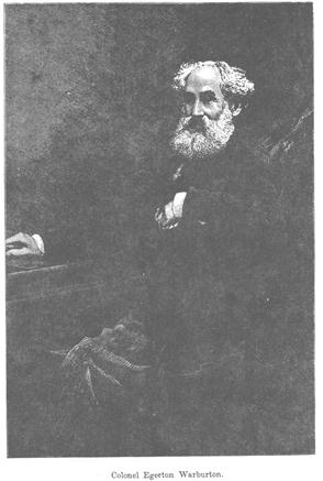
On 3 September 1873, on his way from the Overland Telegraph line at Alice Springs enroute to Joanna Spring then the Oakover River and eventually Roebourne, Warburton went to the top of Mount Romilly (subsequently named by Carnegie) and, on 5 September continuing his generally westward track about 25 km further on, he passed just to the north of Well 47 on the future Canning Stock Route.
Warburton's journal reads:
August 31st. 1873 —Halted for the day. Shot all we could, but the lake is too large for good sport.
September 1st.—We left the lake, and at four miles west-north-west found another; this second was circular, with beautifully clear, fresh water resting on a pebbly bed. The shelving banks were dry, but there was a considerable body of deep water in the centre. From here we made fourteen miles, with very thick spinifex part of the way.
On the 30th, just before reaching the lake, we had captured a young native woman; this was considered a great triumph of art, as the blacks all avoided us as though we had been plague-stricken. We kept her a close prisoner, intending that she should point out native wells to us; but whilst we were camped to-day the creature escaped from us by gnawing through a thick hair-rope, with which she was fastened to a tree. We were quickly on her tracks, directly we discovered our loss, but she was too much for us, and got clear away. We had not allowed her to starve during her captivity, but she supplied herself from the head of a juvenile relation with an article of diet which our stores did not furnish.
2nd.—West again to-day, eighteen miles over bad sand-hills and rough spinifex. Ran up a smoke, and found a native well. There are hills in sight; those towards the north look high and hopeful, but they are quite out of our course. Other detached, broken hills lie to the west, so our intention is to go towards them.
3rd.—North-west by west, to a sandstone hill, (Carnegie notes: probably Mount Romilly) but, arrived at the top, nothing was to be seen from it except several "hunting smokes" in different directions. Found a deep well in a gully some distance up the hill, but we could not use it, for, when cleared out, the sides fell, and it was dangerous for any one to descend. (Well 47 on the Canning Stock Route is about 20km to the west of Mount Romilly.)
4th.—Marched six miles west, and found a native camp and a well. Could not catch a native there, they being too quick for us; not far, how-over, from the camp a howling, hideous old hag was captured, and, warned by the former escape, we secured this old witch by tying her thumbs behind her back, and haltering her by the neck to a tree. She kept up a frightful howling all night, during which time we had to watch her by turns, or she would have got away also. I doubt whether there is any way of securing these creatures if you take your eyes off them for ten minutes. North of us there is rather a good-looking range, running east and west, with a hopeful bluff at its western end (Carnegie notes: probably Twin Heads) but I cannot go farther north whilst there is a hope of getting west. (Near Well 48, the Canning Stock Route passes just to the west of Twin Heads.)
5th.—Made eighteen miles westing over bad country—and no water. (On this day, Warburton passed just to the north of Well 47 on the future Canning Stock Route.)
6th.—Followed a general westerly course, eight miles. Smoke being seen a little to the south, we ran it up, and found a camp and well, but could not see any natives. We let the old witch go. She was the most alarming specimen of a woman I ever saw; she had been of no use to us, and her sex alone saved her from punishment, for under pretence of leading us to some native wells, she took us backwards and forwards over heavy sand-hills, exhausting the camels as well as my small stock of patience. The well we found was in the opposite direction to the one she was taking us to.
Sunday, 7th.—I had hoped for a halt and a good rest for the camels, but our well turned out badly, being very deep, and containing not enough water for us or for a single camel. We could not find anything better, so at sunset I sent the camels back to our last water, remaining myself with one companion at the camp, in charge of our baggage, and as our last well was not a good one, I fear the camels cannot get back for three days. This not only causes great loss of time, which is the same as loss of provisions, but it gives the poor camels too much extra work. We are now on short allowance of flour, and the camels have more before them than they can well do, so they do not stand in need of additional work by going back ; there is, however, no help for it.
8th, 9th, and 10th.—I and my comrade remain at camp. At 11.30 a.m. the party and camels returned; there had been much difficulty and hard work in watering them, the supply being scanty, and it took a whole night as well as the day to satisfy them. The heat is now very great, and the camels are suffering from travelling during the day over the hot sand and steep hills; we are therefore obliged to send them on in the evening, but I shall continue day travelling myself, as long as I can get a camel to stand up.
Source: Warburton, Peter Egerton, Colonel, C M G, Journey Across The Western Interior Of Australian, Sampson Low, Marston, Low, & Searle, London, 1875. Facsimile edition, Hesperian Press, Victoria Park, 1981. (To fit economically into this document some minor format and font changes have been made.)
Extract only from:
Explorations in Australia
by John Forrest
1. EXPLORATIONS IN SEARCH OF DR. LEICHARDT AND PARTY.
2. FROM PERTH TO ADELAIDE, AROUND THE GREAT AUSTRALIAN BIGHT.
3. FROM CHAMPION BAY, ACROSS THE DESERT TO THE TELEGRAPH AND TO ADELAIDE.
WITH AN APPENDIX ON THE CONDITION OF WESTERN AUSTRALIA.
BY JOHN FORREST, F.R.G.S.
ILLUSTRATIONS BY G.F. ANGAS.
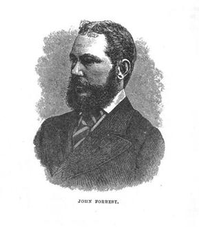
London:
SAMPSON LOW, MARSTON, LOW, & SEARLE,CROWN BUILDINGS, 188, FLEET STREET.
1875.
LONDON: GILBERT AND RIVINGTON, PRINTERS, ST JOHN'S SQUARE.
John Forrest, afterwards Sir John Forrest, and later Baron Forrest of Bunbury, the first Australian raised to the British Peerage, did magnificent exploration work during his early years. At the age of 22, on his first expedition undertaken in 1869, mainly to find the remains of Leichhardt, he travelled over 2,000 miles in the interior of Western Australia. He discovered and named Lake Barlee and Mounts Ida, Leonora, Malcolm, and Margaret. Later, Forrest, in company with his brother, Alexander, in the face of almost incredible difficulties, succeeded in finding an overland route from Perth to South Australia, completing the journey in five months. Until his death in 1918, Lord Forrest was prominent in Australian public life. He was Premier of Western Australia for ten years and for many years represented the Swan electorate of that State, in the Federal Parliament, of which he was a foundation member. Alexander Forrest was, for many years, a member of the Legislative Council of West Australia and for 6 years mayor of Perth and a C.M.G.
FRERE RANGES. (May 1874) 27th. Followed up the Kennedy Creek, bearing North-North-East and North for about seven miles, passing a number of shallow pools, when we came to some splendid springs, which I named the Windich Springs, after my old and well-tried companion Tommy Windich, who has now been on three exploring expeditions with me. They are the best springs I have ever seen--flags in the bed of the river, and pools twelve feet deep and twenty chains long--a splendid place for water. We therefore camped, and found another spot equally good a quarter of a mile west of camp in another branch. There is a most magnificent supply of water and feed--almost unlimited and permanent. A fine range of hills bore north-west from the springs, which I named Carnarvon Range, after the Right Honourable the present Secretary of State for the Colonies. The hills looked very remarkable, being covered with spinifex almost to their very summit. We shot five ducks and got three opossums this afternoon, besides doing some shoeing. There is an immense clump of white gums at head of spring. Barometer 28.34; thermometer 46 degrees at 11 p.m. Marked a large white gum-tree F 41 on west side close to right bank of river, being our 41st camp from Geraldton. Latitude 25 degrees 22 minutes 26 seconds South, longitude about 120 degrees 42 minutes East. (Windich Springs were to become No 4A Water on the Canning Stock Route.)
MOUNT SALVADO. 28th. Steering North 30 degrees East for eleven miles, we came to a rough hill, which I ascended, camped on north side of it, and found water in a gully. The view was very extensive but not promising--spinifex being in every direction. A bold hill bore North 31 degrees East magnetic, about seven miles distant to the North-North-West, which I named Mount Salvado, after Bishop Salvado, of Victoria Plains, a contributor to the Expedition Fund. The Carnarvon Ranges looked very remarkable. To the East and North-East spinifex and low ranges for fifteen miles, when the view was intercepted by spinifex rises--altogether very unpromising. Barometer 28.26; thermometer 70 degrees at 5 p.m.; latitude 25 degrees 24 minutes 11 seconds South.
29th. Steered East-North-East for seven miles, when we came to some fine water in a gully, which we did not camp at, owing to my being ahead with Windich, and my brother not seeing a note I left telling him to remain there while I went on to get a view ahead. Passing this at ten miles, we reached a low spinifex hill capped with rock, from which a remarkable hill was visible, which I named Mount Davis, after my friend Mr. J.S. Davis, who was a contributor to the Expedition Fund. Mount Salvado was also visible. Spinifex in every direction, and the country very miserable and unpromising. I went ahead with Windich. Steering about North 15 degrees East for about eight miles over spinifex sand-hills, we found a spring in a small flat, which I named Pierre Spring, after my companion Tommy Pierre. It was surrounded by the most miserable spinifex country, and is quite a diamond in the desert. We cleared it out and got sufficient water for our horses. To the North, South, and East nothing but spinifex sand-hills in sight. Barometer 28.44; thermometer 70 degrees at 5 p.m.; latitude 25 degrees 14 minutes 34 seconds South by Altair. (Pierre Spring became the site of Well 6 on Canning Stock Route. Tommy Windich and Tommy Pierre were Aboriginal guides with Forrest's party.)
SEARCHING FOR WATER.30th. Steering East-North-East over spinifex red sand-hills for nine miles, we came to a valley and followed down a gully running North-North-East for two miles, when it lost itself on the flat, which was wooded and grassy. About a mile farther on we found a clay-pan with water, and camped, with excellent feed. The country is very dry, and I should think there has not been any rain for several months. The appearance of the country ahead is better than it looked yesterday. I went onwards with Windich to-day, and found the water. Barometer 28.46; thermometer 66 degrees at 5.30 p.m.; latitude 25 degrees 10 minutes 32 seconds.
June 1st.1874 Barometer 28.38; thermometer 45 degrees at 8 a.m. In collecting the horses we came on an old native camp, and found the skull of a native, much charred, evidently the remains of one who had been eaten. Continued on about North-East along a grassy flat, and at five miles passed some clay-pans of water, after which we encountered spinifex, which continued for fifteen miles, when we got to a rocky range, covered with more spinifex. Myself and Windich were in advance, and after reaching the range we followed down a flat about North for six miles, when it joined another large water-course, both trending North-North-West and North-West. We followed down this river for about seven miles, in hopes of finding water, without success. Night was fast approaching, and I struck north for four miles to a range, on reaching which the prospect was very poor; it proved to be a succession of spinifex sand-hills, and no better country was in view to the North-East and East. It was just sundown when we reached the range; we then turned east for two miles, and south, following along all the gullies we came across, but could find no water. It was full moon, so that we could see clearly. We turned more to the westward and struck our outward tracks, and, following back along them, we met the party encamped at the junction of the two branches mentioned before. We kept watch over the horses to keep them from straying. Mine and Windich's horses were nearly knocked up, and Windich himself was very ill all night. Latitude 24 degrees 55 minutes 19 seconds South.
AT WELD SPRINGS. 2nd. Early this morning went with Pierre to look for water, while my brother and Windich went on the same errand. We followed up the brook about south for seven miles, when we left it and followed another branch about South-South-East, ascending which, Pierre drew my attention to swarms of birds, parroquets, etc., about half a mile ahead. We hastened on, and to our delight found one of the best springs in the colony. It ran down the gully for twenty chains, and is as clear and fresh as possible, while the supply is unlimited.
Overjoyed at our good fortune, we hastened back, and, finding that my brother and Windich had not returned, packed up and shifted over to the springs, leaving a note telling them the good news. After reaching the springs we were soon joined by them. They had only found sufficient water to give their own horses a drink; they also rejoiced to find so fine a spot. Named the springs the Weld Springs, after his Excellency Governor Weld, who has always taken such great interest in exploration, and without whose influence and assistance this expedition would not have been organized. There is splendid feed all around. I intend giving the horses a week's rest here, as they are much in want of it, and are getting very poor and tired. Barometer 28.24; thermometer 71 degrees at 5 p.m. Shot a kangaroo. (Weld Springs became the site for Well 9 on the Canning Stock Route.)
7th (Sunday). Pierre shot an emu, and the others shot several pigeons. This is a splendid spot; emus and kangaroos numerous, pigeons and birds innumerable, literally covering the entire surface all round the place in the evenings. We have been living on game ever since we have been here. Intend taking a flying trip to-morrow; party to follow on our tracks on Tuesday. Read Divine Service. Barometer 28.38; thermometer 55 degrees at 7 p.m.
8th. Started with Tommy Pierre to explore the country East-North-East for water, leaving instructions for my brother to follow after us to-morrow with the party. We travelled generally East-North-East for twenty miles over spinifex and undulating sand-hills, without seeing any water. We turned east for ten miles to a range, which we found to be covered with spinifex. Everywhere nothing else was to be seen; no feed, destitute of water; while a few small gullies ran out of the low range, but all were dry. Another range about twenty-four miles distant was the extent of our view, to which we bore. At twenty miles, over red sandy hills covered with spinifex and of the most miserable nature, we came to a narrow samphire flat, following which south for two miles, we camped without water and scarcely any feed. Our horses were knocked up, having come over heavy ground more than fifty miles. The whole of the country passed over to-day is covered with spinifex, and is a barren worthless desert.
BACK TO THE SPRINGS. 9th. At daybreak continued east about four miles to the range seen yesterday, which we found to be a low stony rise, covered with spinifex. The view was extensive and very gloomy. Far to the north and east, spinifex country, level, and no appearance of hills or water-courses. To the south were seen a few low ranges, covered also with spinifex; in fact, nothing but spinifex in sight, and no chance of water. Therefore I was obliged to turn back, as our horses were done up. Travelling south for five miles, we then turned West-North-West until we caught our outward tracks, and, following them, we met the party at 3 o'clock, coming on, about twenty miles from the Weld Springs. Our horses were completely done up. We had not had water for thirty-one hours. We all turned back, retreating towards the springs, and continued on till 10 o'clock, when we camped in the spinifex and tied up the horses.
FIGHT WITH THE NATIVES. 13th. About one o'clock Pierre saw a flock of emus coming to water, and went off to get a shot. Kennedy followed with the rifle. I climbed up on a small tree to watch them. I was surprised to hear natives' voices, and, looking towards the hill, I saw from forty to sixty natives running towards the camp, all plumed up and armed with spears and shields. I was cool, and told Sweeney to bring out the revolvers; descended from the tree and got my gun and cooeyed to Pierre and Kennedy, who came running. By this time they were within sixty yards, and halted. One advanced to meet me and stood twenty yards off; I made friendly signs; he did not appear very hostile. All at once one from behind (probably a chief) came rushing forward, and made many feints to throw spears. He went through many manoeuvres, and gave a signal, when the whole number made a rush towards us, yelling and shouting, with their spears shipped. When within thirty yards I gave the word to fire: we all fired as one man, only one report being heard. I think the natives got a few shots, but they all ran up the hill and there stood, talking and haranguing and appearing very angry. We re-loaded our guns, and got everything ready for a second attack, which I was sure they would make. We were not long left in suspense. They all descended from the hill and came on slowly towards us. When they were about 150 yards off I fired my rifle, and we saw one of them fall, but he got up again and was assisted away. On examining the spot we found the ball had cut in two the two spears he was carrying; he also dropped his wommera, which was covered with blood. We could follow the blood-drops for a long way over the stones. I am afraid he got a severe wound. My brother and Windich being away we were short-handed. The natives seem determined to take our lives, and therefore I shall not hesitate to fire on them should they attack us again. I thus decide and write in all humility, considering it a necessity, as the only way of saving our lives. I write this at 4 p.m., just after the occurrence, so that, should anything happen to us, my brother will know how and when it occurred.
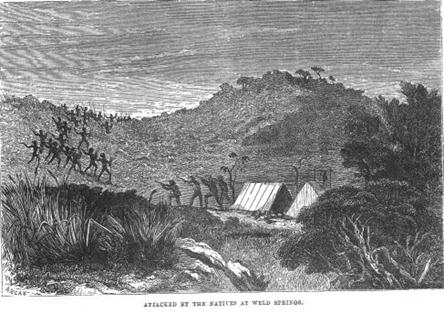
5 p.m. The natives appear to have made off. We intend sleeping in the thicket close to camp, and keeping a strict watch, so as to be ready for them should they return to the attack this evening. At 7.30 my brother and Windich returned, and were surprised to hear of our adventure. They had been over fifty miles from camp East-South-East, and had passed over some good feeding country, but had not found a drop of water. They and their horses had been over thirty hours without water.
14th (Sunday). The natives did not return to the attack last night. In looking round camp we found the traces of blood, where one of the natives had been lying down. This must have been the foremost man, who was in the act of throwing his spear, and who urged the others on. Two therefore, at least, are wounded, and will have cause to remember the time they made their murderous attack upon us. We worked all day putting up a stone hut, ten by nine feet, and seven feet high, thatched with boughs. We finished it; it will make us safe at night. Being a very fair hut, it will be a great source of defence. Barometer 28.09; thermometer 68 degrees at 5 p.m. Hope to have rain, as without it we cannot proceed.
15th. Finished the hut, pugging it at the ends, and making the roof better. Now it is in good order, and we are quite safe from attack at night, should they attempt it again, which I think is doubtful, as they got too warm a reception last time. I intend going with Windich to-morrow easterly in search of water. Barometer 29.09 at 5 p.m.; thermometer 62 degrees. (Remains of hut still clearly visible in 2007.)
16th. Left the Weld Springs with Windich and a pack-horse carrying fourteen gallons of water. Steered South-East for twelve miles over spinifex, after which we got into a grassy ravine, which we followed along three miles, passing some fine clay-holes which would hold plenty of water if it rained. We then turned East-North-East for twelve miles over spinifex, miserable country, when we struck the tracks of my brother and Windich on their return, June 13th. We followed along them South-East for four miles, and then South-East to a bluff range about eighteen miles, which we reached at sundown. Spinifex generally, a few grassy patches intervening, on which were numbers of kangaroos. We camped close to the bluff, and gave the horses one gallon of water each out of the cans. Just when the pannicans were boiled, heard noises which we thought were natives shouting. We instantly put out the fire and had our supper in the dark, keeping a sharp look-out for two hours, when we were convinced it must have been a native dog, as there were hundreds all round us, barking and howling. The weather is heavy and cloudy, and I hope to get some rain shortly. We slept without any fire, but it was not very cold.
Source: downloaded during April- May 2009 from Journals of Australian Land and Sea Explorers and Discoverer; Project Gutenberg Australia e-books accessed at http://gutenberg.net.au/explorers-journals.html (To fit economically into this document some minor format and font changes have been made.)
Ernest Giles
Ernest Giles was born in England in 1835 and educated in London, where he received a classical and literary education. Giles emigrated when he was 15 years old and joined his family in Adelaide. They had come to Australia the previous year. He spent some time working on cattle and sheep stations along the upper Darling River during which time he became a competent bushman. Between 1872 and 1876 he led 5 expeditions into Australia's unknown western interior, the last 2 on camels. He was driven by a desire to be the first to penetrate the area and set out without official support. He was never given material reward for his exploration work, but was awarded the gold medal of the Royal Geographical Society. During his travels he discovered Mount Olga, named the Gibson Desert and crossed the continent from east to west and later went back again by a different route. Despite initial setbacks and seemingly impenetrable wilderness, Giles never weakened in his purpose or his love of exploration. At one point in his travels, he sent his companion, Gibson, on to fetch help, riding their last horse, then struggled along on foot. Gibson was never heard of again. Giles ate the last of his horsemeat and rapidly became weaker. Hunger drove him to eat, whilst still alive, a small dying wallaby, whose mother had evidently thrown it from her pouch. He was so hungry he wished he had its mother and father to "serve in the same way." In 1897 he died after contracting pneumonia whilst working as a clerk in the Coolgardie gold fields. Giles styled himself as the last of the Australian explorers.
Extract only from:
AUSTRALIA TWICE TRAVERSED:
The Romance of Exploration,
BEING
A NARRATIVE COMPILED FROM THE JOURNALS
OF
FIVE EXPLORING EXPEDITIONS
INTO AND THROUGH
Central South Australia, and Western Australia,
FROM 1872 TO 1876.
BY
ERNEST GILES
Fellow, and Gold Medallist, of the Royal Geographical Society of London.
GO FORTH, MY BOOK, AND SHOW THE THINGS,
PILGRIMAGE UNTO THE PILGRIM BRINGS.
Bunyan.
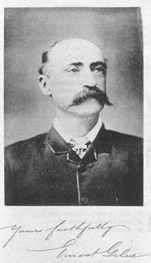
On the 13th of May (1876) we came to a very strange spot, where a number of whitish, flat-topped hills hemmed in the river, and where the conjunction of three or four other creeks occurred with the Ashburton, which now appeared to come from the south, its tributaries coming from the east and north-east. On the most northerly channel, Peter Nicholls shot a very large snake; it was nearly nine feet long, was a foot round the girth, and weighed nearly fifty pounds. It was a perfect monster for Australia. Had we been without food, what a godsend it would have been to us! It would have made two or three good meals for the whole party. I called this place the Grand Junction Depot, as the camp was not moved from there for thirteen days. The position of the camp at this Grand Junction was in latitude 24° 6´ 8´´, and longitude 119°. At this time I had a second attack of ophthalmia; but on the 15th, thinking I was recovering, I went away in company with Alec Ross to penetrate as far north as the 23rd parallel of latitude, as I was in hopes of finding some new hills or ranges in that locality that might extend for a distance eastwards. We took four camels with us, three being the same animals which Alec and I took when we found the Boundary Dam.
Leaving the depot, we went up the most easterly of the creeks that came in at the Grand Junction. In its channel I saw some of the milk or sow-thistle plant growing—the Sonchus oleraceus. I have met this plant in only four places during my explorations. The trend of the creek was nearly from the east-north-east. At six miles the gum-timber disappeared from the creek, and the channel being confined by hills, we were in a kind of glen, with plenty of running water to splash through. A great quantity of tea-tree—Melaleuca—grew in the creek bed. There we saw another large snake, but not of such dimensions as Nicholls's victim. At ten miles up from the depot the glen ceased, and the creek ran through a country more open on the north bank. We camped at about twenty miles. During the day we saw some native poplars, quandong, or native peach, capparis, or native orange, and a few scented sandal-wood-trees; nearly all of these different kinds of trees were very stunted in their growth. At night my eyes were so much inflamed and so painful with ophthalmia, that I could scarcely see. The next day we steered north-north-east, the ground being very stony and bad for travelling. We passed some low hills at seven or eight miles, and at twenty-one we encamped in a dry, stony creek channel. The following day the country was almost identical in its nature, only that we found a small pool of water at night in a creek, our course being still the same. My eyes had been so bad all day, I was in agony; I had no lotion to apply to them. At length I couldn't see at all, and Alec Ross had to lead the camels, with mine tied behind them. I not only couldn't see, I couldn't open my eyes, and had no idea where I was going. That day Alec sighted a range of somewhat high hills to our left; he next saw another range having rounded, dome-like masses about it, and this lay across our path. Alec ascended one of the hills, and informed me that he saw an extensive mass of hills and ranges in every direction but the east. To the north they extended a great distance, but they rose into the highest points at two remarkable peaks to the north-west, and these, although I cannot be certain exactly where they are situated, I have named respectively Mount Robinson and The Governor, in the hope that these designations will remain as lasting memorials of the intelligent and generous interest displayed by Governor Robinson in the exploration of the province under his sway. The country to the east is all level; no ranges whatever appear in that direction. From what Alec saw and described to me, it was evident that we were upon the edge of the desert, as if the ranges ceased to the east, it was not likely that any watercourses could exist without them. No watercourses could be seen in any direction, except that from which we had come. It was a great disappointment to me to get such information, as I had hoped to discover some creeks or rivers that might carry me some distance farther eastward; but now it was evident they did not exist. I called this range, whose almost western end Alec ascended, Ophthalmia Range, in consequence of my suffering so much from that frightful malady. I could not take any observations, and I cannot be very certain where this range lies. I wanted to reach the 23rd parallel, but as the country looked so gloomy and forbidding farther north, it was useless plunging for only a few miles more into such a smashed and broken region. By careful estimate it was quite fair to assume that we had passed the Tropic of Capricorn by some miles, as my estimated latitude here was 23° 15´, and longitude about 119° 37´. I was in such pain that I ordered an instant retreat, my only desire being to get back to the depot and repose in the shade.
This was the 18th of May, and though the winter season ought to have set in, and cool weather should have been experienced, yet we had nothing of the kind, but still had to swelter under the enervating rays of the burning sun of this shadeless land; and at night, a sleeping-place could only be obtained by removing stones, spinifex, and thorny vegetation from the ground. The latter remark, it may be understood, does not apply to only this one place or line of travel; it was always the case. After returning for a few miles on our outcoming tracks, Alec found a watercourse that ran south-westerly, and as it must eventually fall into the Ashburton, we followed it. In travelling down its course on the 22nd the creek became enclosed by hills on either side, and we found an extraordinary rocky spring. The channel of the creek dropped suddenly down to a lower level, which, when in flood, must no doubt form a splendid cascade. Now a person could stand on a vast boulder of granite and look down at the waters, as they fell in little sprays from the springs that supplied the spot; the small streams rushing out from among the fissures of the broken rocks, and all descending into a fine basin below. To Alec's eyes was this romantic scene displayed. The rocks above, below, and around, were fringed and decked with various vegetations; shrubs and small trees ornamented nearly the whole of the surrounding rocks, amongst which the native fig-tree, Ficus platypoda, was conspicuous. It must have been a very pretty place. I could hear the water rushing and splashing, but could not see anything. It appeared also that the water ran out of the basin below into the creek channel, which goes on its course apparently through or into a glen. I describe this peculiar freak of nature from what Alec told me; I hope my description will not mislead others. Soon after we found that this was the case, as we now entered an exceedingly rough and rocky glen full of water—at least so it appeared to Alec, who could see nothing but water as far down as he could look. At first the water was between three and four feet deep; the farther we went the deeper the water became. Could any one have seen us we must have presented a very novel sight, as the camels got nearly up to their humps in water, and would occasionally refuse to go on; they would hang back, break their nose-ropes, and then lie quietly down until they were nearly drowned. We had to beat and pull them up the best way we could. It was rather disagreeable for a blind man to slip off a camel up to his neck in cold water, and, lifting up his eyelids with both hands, try to see what was going on.
Having, however, gone so far, we thought it best to continue, as we expected the glen to end at any turn; but the water became so deep that Alec's riding cow Buzoe, being in water deep enough for her to swim in, if she could swim, refused to go any farther, and thought she would like to lie down. This she tried, but the water was too deep for her to keep her head above it, and after being nearly smothered she got up again:—
“And now to issue from the glen,
No pathway meets the wand'rers' ken,
Unless they climb, with footing nice,
A far-projecting precipice.”
It would be out of all propriety to expect a camel to climb a precipice; fortunately at a few yards further a turn of the glen showed Alec a place on the southern bank where a lot of rocks had fallen down. It was with the greatest difficulty we got to it, and with still greater that at last we reached the top of the cliff, and said good-bye to this watery glen. Our clothes, saddles, blankets, and food were soaked to a pulp. We could not reach the depot that night, but did so early on the following day. I called this singular glen in which the camels were nearly drowned, Glen Camel.
No natives had visited the camp, nor had any living thing, other than flies, been seen, while we were away, except a few pigeons. The camp at this depot was fixed on the soft, sandy bed of the Ashburton, close to the junction of the east creek, which Alec and I had followed up. It had been slightly flooded by the late rains, and two open ponds of clear water remained in the bed of the Ashburton. It seems probable that water might always be procured here by digging, but it is certainly not always visible on the surface. Once or twice before reaching the depot, we saw one or two places with dried-up bulrushes growing in the bed, and water may have existed there in the sand. In consequence of my eyes being so bad, we remained here for the next two days. The heat and the flies were dreadful; and the thermometer indicated 93° one day and 95° the next, in the shade. It was impossible to get a moment's peace or rest from the attacks of the flies; the pests kept eating into our eyes, which were already bad enough. This seemed to be the only object for which these wretches were invented and lived, and they also seemed to be quite ready and willing to die, rather than desist a moment from their occupation. Everybody had an attack of the blight, as ophthalmia is called in Australia, which with the flies were enough to set any one deranged. Every little sore or wound on the hands or face was covered by them in swarms; they scorned to use their wings, they preferred walking to flying; one might kill them in millions, yet other, and hungrier millions would still come on, rejoicing in the death of their predecessors, as they now had not only men's eyes and wounds to eat, but could batten upon the bodies of their slaughtered friends also. Strange to say, we were not troubled here with ants; had we been, we should only have required a few spears stuck into us to complete our happiness. A very pretty view was to be obtained from the summit of any of the flat-topped hills in this neighbourhood, and an area of nearly 100 square miles of excellent country might be had here.
On Friday, the 26th of May, we left the depot at this Grand Junction. The river comes to this place from the south for some few miles. In ten miles we found that it came through a low pass, which hems it in for some distance. Two or three tributaries joined, and above them its bed had become considerably smaller than formerly. At about eighteen miles from the depot we came upon a permanent water, fed by springs, which fell into a fine rock reservoir, and in this, we saw many fish disporting themselves in their pure and pellucid pond. Several of the fishes were over a foot long. The water was ten or more feet deep. A great quantity of tea-tree, Melaleuca, grew in the river-bed here; indeed, our progress was completely stopped by it, and we had to cut down timber for some distance to make a passage for the camels before we could get past the place, the river being confined in a glen. Peter Nicholls was the first white man who ever saw this extraordinary place, and I have called it Nicholls's Fish Ponds after him. It will be noticed that the characteristics of the only permanent waters in this region are rocky springs and reservoirs, such as Saleh's Fish Ponds, Glen Ross, Glen Camel, and Nicholls's Fish Ponds will show. More junctions occurred in this neighbourhood, and it was quite evident that the main river could not exist much farther, as immediately above every tributary its size became manifestly reduced.
On the 27th of May we camped close to a red hill on the south bank of the river; just below it, was another spring, at which a few reeds and some bulrushes were growing. The only views from any of the hills near the river displayed an almost unvarying scene; low hills near the banks of the river, and some a trifle higher in the background. The river had always been in a confined valley from the time we first struck it, and it was now more confined than ever. On the morning of the 28th of May we had a frost for the first time this year, the thermometer indicating 28°. To-day we crossed several more tributaries, mostly from the north side; but towards evening the river split in two, at least here occurred the junction of two creeks of almost equal size, and it was difficult to determine which was the main branch. I did not wish to go any farther south, therefore I took the more northerly one; its trend, as our course for some days past had been, was a good deal south of east; indeed, we have travelled about east-south-east since leaving the depot. In the upper portions of the river we found more water in the channel than we had done lower down; perhaps more rain had fallen in these hills.
By the 29th, the river or creek-channel had become a mere thread; the hills were lowering, and the country in the glen and outside was all stones and scrub. We camped at a small rain-water hole about a mile and a half from a bluff hill, from whose top, a few stunted gum-trees could be seen a little farther up the channel. Having now run the Ashburton up to its head, I could scarcely expect to find any more water before entering Gibson's Desert, which I felt sure commences here. So far as I knew, the next water was in the Rawlinson Range of my former horse expedition, a distance of over 450 miles. And what the nature of the country between was, no human being knew, at least no civilised human being.
I was greatly disappointed to find that the Ashburton River did not exist for a greater distance eastwards than this, as when I first struck it, it seemed as though it would carry me to the eastwards for hundreds of miles. I had followed it only eighty or a trifle more, and now it was a thing of the past.
It may be said to rise from nowhere, being like a vast number of Australian rivers, merely formed in its lower portions by the number of tributaries that join it. There are very few pretty or romantic places to be seen near it. The country and views at the Grand Junction Depot form nearly the only exceptions met. From that point the river decreased in size with every branch creek that joined it, and now it had decreased to nothing. No high ranges form its head. The hills forming its water-shed become gradually lower as we approach its termination, or rather beginning, at the desert's edge. The desert's edge is a raised plateau of over 2000 feet above the sea-level—the boiling point of water being 208° = 2049 feet—and being about 350 miles in a straight line from where the Ashburton debouches into the sea. My camp upon the evening of the 29th of May, a little westward of the bluff-faced hill before mentioned, was in latitude 24° 25´ and longitude 119° 58´. We remained here during the 30th. The horizon to the east was formed by a mass of low ranges; from them we saw that several diminutive watercourses ran into our exhausted channel. I could not expect that any hills would extend much farther to the east, or that I should now obtain any water much farther in that direction. A line of low ridges ran all round the eastern horizon, and another bluff-faced hill lay at the south-west end of them. The whole region had a most barren and wretched appearance, and there was little or no vegetation of any kind that the camels cared to eat. Feeling certain that I should now almost immediately enter the desert, as the explorer can scent it from afar, I had all our water-vessels filled, as fortunately there was sufficient water for the purpose, so that when we leave this camp we shall not be entirely unprepared.
The morning of the 31st of May was again cold, the thermometer falling to 27°, and we had a sharp frost. I was truly delighted to welcome this long-expected change, and hoped the winter or cool season had set in at last. This day we travelled east, and went over low, rough ridges and stony spinifex hills for several miles. At about eleven miles, finding a dry water-channel, which, however, had some good camel shrubs upon its banks, we encamped in latitude 24° 28´, being still among low ridges, where no definite view could be obtained. On June the 1st we travelled nearly east-north-east towards another low ridge. The ground became entirely covered with spinifex, and I thought we had entered the desert in good earnest; but at about six miles we came upon a piece of better country with real grass, being much more agreeable to look at. Going on a short distance we came upon a dry water-channel, at which we found a deep native well with bitter water in it. We encamped in latitude 24° 24´. The night and following morning were exceedingly cold—the thermometer fell to 18°. We had not yet reached the low ridge, but arrived at it in two miles on the morning of the 2nd. From it another low ridge bore 23° north of east, and I decided to travel thither.
To-day we had a good deal of country covered with ironstone gravel; we passed a few grassy patches with, here and there, some salt bush and acacia flats; there were also many desert shrubs and narrow thickets. The camp was fixed nearly under the brow of the ridge we had steered for, and it was quite evident, though a few ridges yet appeared for a short distance farther east, that we had at length reached the desert's edge and the commencement of the watershed of the western coast. It will be observed that in my journey through the scrubs to Perth, I had met with no creeks or water-sheds at all, until after I reached the first outlying settlement.
The question which now arose was, what kind of country existed between us and my farthest watered point in 1874 at the Rawlinson Range? In a perfectly straight line it would be 450 miles. The latitude of this camp was 24° 16´ 6´´. I called it the Red Ridge camp. Since my last attack of ophthalmia, I suffer great pain and confusion when using the sextant. The attack I have mentioned in this journey was by no means the only one I have had on my numerous journeys; I have indeed had more or less virulent attacks for the last twenty years, and I believe the disease is now chronic, though suppressed. From the Red Ridge camp we went about eight miles east-north-east, and I found under a mass of low scrubby hills or rises tipped with red sandstone, a rocky cleft in the ground, round about which were numerous old native encampments; I could see water under a rock; the cleft was narrow, and slanted obliquely downwards; it was not wide enough to admit a bucket. There was amply sufficient water for all my camels, but it was very tedious work to get enough out with a quart pot; the rock was sandstone. There was now no doubt in my mind, that all beyond this point was pure and unrelieved desert, for we were surrounded by spinifex, and the first waves of the dreaded sandhills were in view. The country was entirely open, and only a sandy undulation to the eastward bounded the horizon. The desert had to be crossed, or at least attempted, even if it had been 1000 miles in extent; I therefore wasted no time in plunging into it, not delaying to encamp at this last rocky reservoir. After watering our camels we made our way for about four miles amongst the sandhills. As we passed by, I noticed a solitary desert oak-tree, Casuarina decaisneana, and a number of the Australian grass-trees, Xanthorrhoea. The country was almost destitute of timber, except that upon the tops of the parallel lines of red sandhills, which mostly ran in a north-east and south-west direction, a few stunted specimens of the eucalypt, known as blood-wood or red gum existed. This tree grows to magnificent proportions in Queensland, and down the west coast from Fremantle, always in a watered region. Heaven only knows how it ever got here, or how it could grow on the tops of red sandhills. Having stopped to water our camels at the rocky cleft, our first day's march into the desert was only eleven miles. Our camp at night was in latitude 24° 12´ 22´´.
The next day all signs of rises, ridges, hills, or ranges, had disappeared behind the sandhills of the western horizon, and the solitary caravan was now launched into the desert, like a ship upon the ocean, with nothing but Providence and our latitude to depend upon, to enable us to reach the other side.
The following morning, Sunday, the 4th June, was remarkably warm, the thermometer not having descended during the night to less than 60°, though only two mornings ago it was down to 18°. I now travelled so as gradually to reach the 24th parallel, in hopes some lines of hills or ranges might be discovered near it. Our course was east by north. We had many severe ridges of sand to cross, and this made our rate of travelling very slow. We saw one desert oak-tree and a few currajong-trees of the order of Sterculias, some grass-trees, quandong, or native peach, Fusanus, a kind of sandal-wood, and the red gum or blood-wood-trees; the latter always grows upon ground as high as it can get, and therefore ornaments the tops of the sandhills, while all the first-named trees frequent the lower ground between them. To-day we only made good twenty miles, though we travelled until dark, hoping to find some food or proper bushes for the camels; but, failing in this, had to turn them out at last to find what sustenance they could for themselves. On the following morning, when they were brought up to the camp—at least when some of them were—I was informed that several had got poisoned in the night, and were quite unable to move, while one or two of them were supposed to be dying. This, upon the outskirt of the desert, was terrible news to hear, and the question of what's to be done immediately arose; but it was answered almost as soon, by the evident fact that nothing could be done, because half the camels could not move, and it would be worse than useless to pack up the other half and leave them. So we quietly remained and tended our sick and dying ones so well, that by night one of the worst was got on his legs again. We made them sick with hot water, butter, and mustard, and gave them injections with the clyster pipe as well; the only substance we could get out of them was the chewed-up Gyrostemon ramulosus, which, it being nearly dark, we had not observed when we camped. We drove the mob some distance to another sandhill; where there was very little of this terrible scourge, and the next morning I was delighted to find that the worst ones and the others were evidently better, although they were afflicted with staggers and tremblings of the hind limbs. I was rather undecided what to do, whether to push farther at once into the desert or retreat to the last rocky cleft water, now over five-and-twenty miles behind us. But, as Othello says, once to be in doubt is once to be resolved, and I decided that, as long as they could stagger, the camels should stagger on. In about twelve miles Alec Ross and Tommy found a place where the natives had formerly obtained water by digging. Here we set to work and dug a well, but only got it down twelve feet by night, no water making its appearance. The next morning we were at it again, and at fifteen feet we saw the fluid we were delving for. The water was yellowish, but pure, and there was apparently a good supply. We had, unfortunately, hit on the top of a rock that covered nearly the whole bottom, and what water we got came in only at one corner. Two other camels were poisoned in the night, but those that were first attacked were a trifle better.
On the 8th of June more camels were attacked, and it was impossible to get out of this horrible and poisonous region. The wretched country seems smothered with the poisonous plant. I dread the reappearance of every morning, for fear of fresh and fatal cases. This plant, the Gyrostemon, does not seem a certain deadly poison, but as I lost one camel by death from it, at Mr. Palmer's camp, near Geraldton, and so many are continually becoming prostrated by its virulence, it may be well understood how we dread the sight of it, for none can tell how soon or how many of our animals might be killed. As it grows here, all over the country, the unpoisoned camels persist in eating it; after they have had a shock, however, they generally leave it entirely alone; but there is, unfortunately, nothing else for them to eat here.
The weather now is very variable. The thermometer indicated only 18° this morning, and we had thick ice in all the vessels that contained any water overnight; but in the middle of the day it was impossible to sit with comfort, except in the shade. The flies still swarmed in undiminished millions; there are also great numbers of the small and most annoying sand-flies, which, though almost too minute to be seen, have a marvellous power of making themselves felt. The well we put down was sunk in a rather large flat between the sandhills. The whole country is covered with spinifex in every direction, and this, together with the poisonous bushes and a few blood-wood-trees, forms the only vegetation. The pendulous fringe instead of leaves on the poison bush gives it a strange and weird appearance, and to us it always presents the hideous, and terrible form of a deadly Upas-tree.
CHAPTER 5.4. FROM 11TH JUNE TO 23RD AUGUST, 1876.
Farther into the desert. Sandhills crowned with stones. Natives' smokes and footprints seen. Weakened camels. Native well. Ten days' waterless march. Buzoe's grave. A region of desolation. Eagles. Birds round the well. Natives hovering near. Their different smokes. Wallaby. Sad Solitude's triumphant reign. The Alfred and Marie range once more. The Rawlinson range and Mount Destruction. Australia twice traversed. Fort McKellar. Tyndall's Springs. A last search after Gibson. Tommy's Flat. The Circus. The Eagle. Return to Sladen Water. The Petermann tribes. Marvellous Mount Olga. Glen Watson. Natives of the Musgrave range. A robbery. Cattle camps. The missing link. South for the Everard range. Everard natives. Show us a watering-place. Alec and Tommy find water. More natives. Compelled to give up their plunder. Natives assist at dinner. Like banyan-trees. A bad camping-place. Natives accompany us. Find the native well. The Everard revisited. Gruel thick and slab. Well in the Ferdinand. Rock-hole water. Natives numerous and objectionable. Mischief brewing. A hunt for spears. Attack frustrated. Taking an observation. A midnight foe. The next morning. Funeral march. A new well. Change of country. Approaching the telegraph line. The Alberga. Decrepit native women. The Neales. Mount O'Halloran. The telegraph line. Dry state of the country. Hann's Creek. Arrival at the Peake.
On the 11th of June I was delighted to be able to be again upon the move, and leave this detestable poisonous place and our fifteen-foot shaft behind. Our only regret was that we had been compelled to remain so long. The camels had nearly all been poisoned, some very much worse than others; but all looked gaunt and hollow-eyed, and were exceedingly weak and wretched, one remarkable exception being noticed in Alec Ross's riding-cow, old Buzoe, who had either not eaten the poison plant, or had escaped untouched by it. Our course was now east by north, and as we got farther into the desert, I noticed that occasionally some of the undulations of sand were crowned with stones, wherever they came from. Where these stones crop up a growth of timber, generally mulga occurs with them. It is sandstone that tips these rises. Some smokes of native fires were seen from our line of march, in northerly and southerly directions, and occasionally the footprints upon the sands, of some wandering child of the desert.
These were the only indications we could discover of the existence of primordial man upon the scene. We passed a few grass-trees, which are usually called “black boys” in almost every part of the continent where they exist, and they seem to range over nearly the whole of Australia, from Sydney to Perth, south of the Tropic. The camels were so weak that to-day we could only accomplish about eighteen miles. At five miles, on the following morning, we passed a hollow with some mulga acacia in it. Near them Alec and I found a place where the number of deserted huts, or gunyahs of the natives induced us to look about for a well or some other kind of watering-place. An old well was soon found, which was very shallow; the water was slightly brackish and not more than three feet below the surface. How I wished I had known of its existence before, it being not twenty-five miles from our poison camp, and that some good acacia bushes grew here also; as it was, I made no use of it. The weather being cool, and the camels having filled themselves with water at the deep well, they would not drink. That afternoon we got into a hollow where there was a low ridge of flat-topped cliffs, and a good deal of mulga timber in it. Very likely in times of rain a flow of water might be found here, if there ever are times of rain in such a region. We just cleared the valley by night, having travelled nearly twenty miles. My(ie Giles') latitude here was 23° 56´ 20´´ and not desiring to go any farther north, I inclined my course a little southerly—that is to say, in an east by south direction. (By scaling from Giles' chart, at this point he was at longitude 121deg 24' east. During the next unrecorded section of his travel ie between 9&18 June 1876, Giles crossed the future Canning Stock Route to the north of Well 15. This was between the Trainor Hills and the Calvert Range, both named by Lawrence Wells in 1896; but on which Giles' narrative is silent.)
We had left the deep well on the 9th June, and not until ten days of continuous travelling had been accomplished—it being now the 18th—did we see any more water. That evening we reached a little trifling water-channel, with a few small scattered white gum-trees, coming from a low stony mulga-crowned ridge, and by digging in it we found a slight soakage of water. Here we dug a good-sized tank, which the water partly filled, and this enabled us to water all the camels. They had travelled 230 miles from our deep well. For the last two or three days poor old Buzoe, Alec Ross's riding cow, has been very ill, and almost unable to travel; she is old and worn out, poor old creature, having been one of Sir Thomas Elder's original importations from India. She had always been a quiet, easy-paced old pet, and I was very much grieved to see her ailing. I did not like to abandon her, and we had to drag her with a bull camel and beat her along, until she crossed this instalment of Gibson's Desert: but she never left this spot, which I have named Buzoe's Grave. I don't think this old cow had been poisoned—at least she never showed any signs of it; I believe it was sheer old age and decay that assailed her at last. The position of this welcome watered spot was in latitude 24° 33´, and longitude 123° 57´. It was by wondrous good fortune that we came upon it, and it was the merest chance that any water was there. In another day or two there would have been none; as it was, only a little rainwater, that had not quite ceased to drain down the half-stony, half-sandy bed of the little gully, was all we got. The weather had been very disagreeable for some days past, the thermometer in the early dawn generally indicating 18° while in the middle of the day the heat was oppressive.
The flies were still about us, in persecuting myriads. The nature of the country during this march was similar to that previously described, being quite open, it rolled along in ceaseless undulations of sand. The only vegetation besides the ever-abounding spinifex was a few blood-wood-trees on the tops of some of the red heaps of sand, with an occasional desert oak, an odd patch or clump of mallee-trees, standing desolately alone, and perhaps having a stunted specimen or two of the quandong or native peach-tree, and the dreaded Gyrostemon growing among them. The region is so desolate that it is horrifying even to describe. The eye of God looking down on the solitary caravan, as with its slow, and snake-like motion, it presents the only living object around, must have contemplated its appearance on such a scene with pitying admiration, as it forced its way continually on; onwards without pausing, over this vast sandy region, avoiding death only by motion and distance, until some oasis can be found. Slow as eternity it seems to move, but certain we trust as death; and truly the wanderer in its wilds may snatch a fearful joy at having once beheld the scenes, that human eyes ought never again to see. On the 15th of June we found a hollow in which were two or three small salt-lake beds, but these were perfectly dry; on the 16th also another solitary one was seen, and here a few low rises lay across a part of the eastern horizon. On the 17th a little water left in the bottom of a bucket overnight was frozen into a thick cake in the morning, the thermometer indicating 18°. The nights I pass in these fearful regions are more dreadful than the days, for “night is the time for care, brooding o'er days misspent, when the pale spectre of despair comes to our lonely tent;” and often when I lay me down I fall into a dim and death-like trance, wakeful, yet “dreaming dreams no mortals had ever dared to dream before.”
Source: downloaded during April- May 2009 from Journals of Australian Land and Sea Explorers and Discoverer; Project Gutenberg Australia e-books accessed at http://gutenberg.net.au/explorers-journals.html (To fit economically into this document some minor format and font changes have been made.)
Lawrence Allen Wells (1860-1938), was born near Penola, South Australia on 30 April 1860 was the second son of Thomas A. Wells. Lawrence started his career as a bookkeeper in Mount Gambier. In 1878 he started with the South Australian Survey Department. By 1883 he was an assistant surveyor and Surveyor-General George Goyder instructed him to assist Augustus Poeppel with the survey of the Queensland-South Australian boundary. This had started under Poeppel in June 1880 but was found to be in error due to the chain being about 2.5 cm too long. When that job was finished, they then surveyed the Northern Territory-Queensland border. In January 1887 Wells was appointed surveyor and was soon up north again surveying pastoral leases from Charlotte Waters, Birdsville and Innamincka. In 1888, he was surveying pastoral leases on Eyre Peninsula. In 1890 he was surveying the Mutooro run just south of the Broken Hill railway line. When the Elder Scientific Exploring Expedition was planned, Wells was appointed second in command to David Lindsay. Financed by Sir Thomas Elder, the expedition sought to fill in some of the gaps in the maps left by Giles, Gosse, Forrest and Mills. The exploring party of 15 men and 44 camels left the Warrina railhead on 2 May 1891. The party encountered great heat, hardship and thirst, often going days without finding water. On one stretch the camels did not drink for 24 days. Within six weeks it recorded the death of W. Bowden. On 3 October they reached the Frazer Range Station having travelled nearly 4,000 km. David Lindsay travelled a further 250 km to Esperance Bay then owing to personal problems returned to Adelaide in January 1892. Wells became leader of the expedition. The party disbanded in March 1892 although travelling thousands of kilometres they found little of use but Wells did discover evidence of gold near present day Wiluna. Wells married Alice Marion Woods on 22 September 1892; they later had two daughters.
Four years later Wells was in charge of the Calvert Exploring Expedition financed by Albert F. Calvert from London. Its objective was to resume exploring where Wells had turned back in 1892. Later Calvert refused to pay the full cost of the expedition and the South Australian government was asked to cover the difference and the expedition later became known as the Calvert Scientific Exploring Expedition. The party left Port Adelaide on 24 May 1896 for Geralton; arriving on 3 June. On 19 August they crossed Giles' 1876 tracks near Mount Madley. On 11 October the party split at Separation Well with Charles Wells and George Jones travelling further westward and expecting to rejoin the main party at Warburton's Joanna Spring. Struggling to find enough water or feed, and suffering from heat, Wells abandoned most of the equipment at Adverse Well. Being unable to locate Joanna Spring, they then headed for the Fitzroy River, arriving on 6 November. With the help of various locals, including Nat Buchannan, Troopers Pilmer and Nicholson, and Sub-Inspector Craven Ord, four searches were made for Charles Wells and George Jones. Their bodies were found about 14 km from Joanna Spring on 27 May 1897 and brought to Adelaide for burial in the North Road cemetery. (Warburton's positioning of Joanna Spring was about 25 km in error.) After his return to Adelaide, Wells worked for the Pastoral Board as valuator and inspector. In 1903, he led a prospecting expedition northwest of Oodnadatta into the Musgrave Ranges. During 1905-08 he did a trigonometrical survey of the Victoria River district; also mapping the area between Pine Creek and the West Australian border. Camels for this work came from Mount Serle in South Australia. In 1909 he was became South Australian Land Tax Assessor and in 1910 was appointed Federal Deputy Commissioner of Land Tax for South Australia. After his retirement he was involved with the Quest Expedition in 1930 and another prospecting party which travelled between Ooldea and Laverton in Western Australia. In 1932 when 72 he headed an expedition into Central Australia to explore for minerals with Roland Borlace Poyntz who was 73. There was a final expedition in 1933 to Tarcoola. In 1937 Wells was honoured with an OBE. Sadly, on 11 May 1938 he was struck by a railcar which resulted in his death. He was buried at the Micham Anglican Cemetery.
Source, drawn from: Christopher Steele Wells, Lawrence Allen (1860 - 1938), Australian Dictionary of Biography, Volume 12, Melbourne University Press, 1990, pp 440-441. May 2009
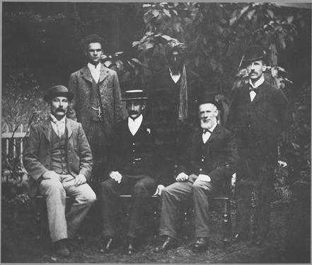
Members of the Calvert Scientific Exploring Expedition
L-R: CF Wells, GL Jones, LA Wells, Bejah, GA Keartland, AT Magarey (Agent)
(However, according to photos in both Cannon and Blackburn seated centre is AF Calvert.)
1902
WESTERN AUSTRALIA
JOURNAL
OF
THE CALVERT SCIENTIFIC EXPLORING
EXPEDITION, 1896-7
Equipped at the request and expense of Albert F. Calvert, Esq.,
F R G S, London for the purpose of Exploring
the remaining blanks of Australia.
Presented to both Houses of Parliament by His Excellency's Command
PERTH
BY AUTHORTITY: WM. ALFRED WATSON, GOVERNMENT PRINTER
1902
No. 46
Members of the Expedition
|
L A Wells |
Leader |
|
C F Wells |
Second in Command |
|
G A Keartland |
Naturalist and representing Botany |
|
G L Jones |
Mineralogist and Photographer |
|
James Trainor |
Cook and Assistant |
|
Bejah |
Afghan in charge of camels |
|
Said Ameer |
Assistant (Afghan) camel-driver |
Equipment
|
20 camels |
|
6 pairs of 25-gallon water kegs |
|
1 pair of 5 gallon water kegs |
|
Stores, instruments, etc |
(Three man, seven camel reconnaissance party travelling north searching for water before bringing up main party, about 200km east of the future Canning Stock Route.)
Wednesday, August 19 (1896).—As the days are becoming much warmer towards afternoon, I have determined upon getting away earlier in the morning. Started at six o'clock, bearing North 41deg. East, over gravelly slopes of mulga and porcupine—good going for camels for the first seven miles. Then, on our right, we noted a forest of large bloodwoods (eucalyptus), with beautiful, green foliage. At eight (8) miles, on rising ground, the vegetation, luxuriant in growth, was of herbage such as waterbush, parakylia, and wildflowers—an indication that there has been a good rain here a few months since. At nine (9) miles the bluff point seen on the 16th inst. was visible, with a mulga-clothed hill or ridge on its East. A small creek, dividing the two and running Southward, empties itself among the bloodwoods and porcupine in the valley we have just crossed. Altered course to North 7deg. East, and, steering direct for the bluff point, we reached it in five (5) miles on this bearing. I make this point the position of Mr. Ernest Giles' "Buzzoe's Grave," and of the small creek or watercourse at which he obtained a scanty supply of water. From the summit of the bluff was also noticeable the low, dark ridge some miles to the Eastward, which is also a feature on his map. From his description of this spot, I did not anticipate finding water here unless our arrival should happen a few days after rain; so I was not disappointed. Continuing our journey and now bearing North 21deg. East, we passed through another gap similar in description to the last—a single, low hill on our East, and clay-rock escarpments and table-tops, capped with quartzite, to the West. We then encountered sandridges and lumpy porcupine flats; bad travelling until, at 4 1/2 miles, the escarpments to the West bore off to the West and South-West. At six miles we reached a prominent hill (Mt. Madley) in the ridge, where we found some good, green herbage, so I decided to camp, rather than risk going further. From the top of the hill, which is 1,750 feet above sea-level and 200 feet above a valley immediately to the North, similar mulga-clothed ridges or low ranges are visible to the Westward, about ten (10) miles distant, with belts of mulga, porcupine and sandridges covering the space intervening. To the North-West nothing is visible for a considerable distance but sandridges and porcupine, whilst to the North-North-East is another low range, to which I purpose proceeding to-morrow. Fresh footprints of natives are to be seen here on the sandridges. Smokes were also seen to the North-East and East-South-East. Travelled for day 20 miles. Latitude by sextant, 24deg. 30min. 59sec. South. (Edited break in text.)
Tuesday, August 25.—Rising long before daylight, after a most restless night, we were moving at 5 a.m. Now bearing North 192deg. East, over wretched country. Crossed, at four (4) miles, a low valley with limestone outcropping and tea-tree up to fifteen (15) feet high, and trending about East and West. A mile further on, while walking a little in advance of the caravan, my attention was drawn to the well-known whirr of the crested bronzewing or wirewing pigeon. I saw the bird flying quickly to the Westward. Although so often disappointed in following birds on the chance of finding water, this bird, on account of the rate at which it was flying, gave me fresh hope, and I accordingly ascended a high sandridge over which I noticed it dip. Noting there from a remarkably green belt of tall tea-tree, I called to Mr. Jones, who was in charge of the camels, to halt and come over. Proceeding to the clump of tea-tree, we saw several pigeons about it, but no water, although we found old camping-places of natives, and saw limestone outcropping in the gully. However, seeing some good camel feed, I determined to camp for the day and institute a careful search. Mr. Jones returned to Bejah to bring the camels over, whilst I followed down a small samphire lead to the North-West. About ten (10) chains down from the clump of tall tea-tree I came to a patch of the same species, only stunted in growth and about four (4) chains wide. In this was a small hollow, at the bottom of which I found a native well filled with sand and debris. The earth was damp on the top, and I came to the conclusion that the pigeons had been sucking the water from it. The caravan arriving, we set to work at once and found we had discovered a really good well of water, slightly saline, but good to drink... We sank through sand for six (6) feet, and then through rubble sandstone for two (2) feet, and the water rose about three (3) feet during the afternoon. I need hardly say how delighted we all were at our good fortune. I felt very thankful to be relieved from the anxiety of the last four (4) days. This water is almost in the heart of the desert, and midway between our depot and Joanna Spring, on Colonel Warburton's route. I have called it "Midway Well." We stayed here for the remainder of the day. The camels enjoyed themselves immensely, and we indulged in the rare luxury of a bath, after fourteen (14) days without a wash of any description. During the afternoon I fired a shot at a pigeon, breaking its legs, but it got away. It afterwards appeared to me a cruel return to perhaps the identical bird that led us to this haven of rest. For we should most certainly have passed it by but for the bird. In fact, it could easily be passed at a distance of three (3) chains without observation. But " man's hand is ever slow to spare and ever ready to strike." At the well there is a large mound of earth and debris, apparently the accumulation of many years, and caused by the natives through the removal of rubbish and silt from the hole. From the hundreds of old camping places on the surrounding sandridges, I am of the opinion that this is a permanent water and a summer resort of the aborigines. However, the well has not been in use for a long period. Owing to the weakness of my eyes, I had difficulty in using the sextant. I make the latitude 23deg. 23min. South and the computed longitude 123deg. 59min. East. (Now on Beadell's Talawanna Track, Midway Well is about 80km south east of Well 24 on the Canning Stock Route.)
(Party turns south west)
Wednesday, August 26.--Having had such excellent good fortune yesterday, I decided to begin to day mapping the country to the South-West, thence travelling Southerly to depot. It will be further to return this way, but my mission is to map in all blank spaces, and not merely to make a bee-line through the country. However, owing to our late start from Adelaide, no delay must occur, and I must get the main party and impedimenta through to this well before the season advances and the heat becomes greater. As it is, the heavily-laden camels will find it a stiff task to tackle again the terrible extent of sandridges we have crossed between here and depot. Watered camels and made a start at 8.30 a.m., bearing North 246deg. East, with the intention of travelling about this course to Mr. Ernest Giles' route, and thence Southerly for depot. We crossed over a wretched desert country for the whole day, the sandridges in places being one hundred (100) feet high. Saw no camel feed, but plenty of poison plant, until, at fourteen (14) miles, we camped on a few wattle bushes and native poplars. The day was very hot. Tied camels up for the night.
Thursday, August 27.—Started at 5.30 a.m. and still on same course; travelled over a jumble of sandridges for four (4) miles, when I noted a valley in front of us with small saline flats and tea-tree. Half-a-mile further on and half-a-mile to the right appeared another saline flat or claypan, to which we proceeded. Seeing two (2) corella parrots and some pigeons, we made a search and found a well filled with debris, but with water near the surface, which was very brackish and bitter. There were flocks of shell parrots flying over us, and going from East to West. There must be a good water not far distant, but it is impossible to say whether the birds are going to or from water. From a high sandridge I could see a lagoon (apparently salt) a few miles distant and bearing forth 305deg East. There is abundance of limestone here, and good camel feed. Numbers of quandong (or native peach trees) abound, bearing the most luxuriant fruit I have ever seen. Some of the peaches are as large as egg-plums. From one (1) tree we almost filled a 501b. flour-bag, without by any means stripping it of all its fruit. We are now really crossing a valley of low sandridges and limestone outcrops, wooded with mallee, wattle bushes, grevillia, tea-tree, and porcupine, which appears to grow anywhere. At seven (7) miles we crossed a shallow samphire and saltbush lead trending in the direction of the lagoon. More high, red sandridges at nine (9) miles. At twelve (12) miles we found another open flat of samphire and saltbush a half-mile on our right (North-West), with a larger valley in front of us. Finding good camel feed, I decided to camp at 11 a.m. in a belt of tea-tree. There is quandong here also, and a large species of dark wattle (acacia). Latitude at camp, 23deg. 31min. 20sec. South.
Friday, August 28.—Allowed the camels to feed at 3.30 a.m., and, breakfasting, we again pushed on. Following same course, we crossed the valley, which shows gypsum and limestone, at two (2) miles, noticing mallee (eucalyptus), tea-tree, quandong with excellent fruit, grevillia, and a little coarse grass. We then toiled over sandridges and through porcupine for the remainder of the day. For the first ten (10) miles the ridges were very high, some over one hundred (100) feet, and crowned with loose, red drift. We saw no feed for the last fifteen (15) miles, and camped at twenty-two (22) miles on a few wattle bushes for the camels. At fourteen (14) miles I was surprised to see a very remarkable dome or cone-shaped hill (Cromer Cone) of sandstone, standing alone a few miles to the North-West; and also a small peak at the end of a low range, which is partly covered by sandridges. From camp another low range, about fifteen (15) miles distant, bears North 305deg. East. We have seen neither smokes nor tracks of natives for a week—a sure sign that there are not any in the country at present, as they are continually burning the country wherever they are located. (Cromer Cone is on the eastern side of Lake Disappointment about 45 km south of Well 24 on the Canning Stock Route.)
Saturday, August 29.—Started at 6.40 a.m.; still on same bearing, crossing same and desolate-looking country. At five (5) miles, from the summit of a high sandridge, noticed hills and ranges in front of us. Almost due West was a bluff or headland at the end of a bold-looking hill in a keg range (Runton Range), with three (3) conspicuous detached hills to the West-South-West. There is a very distant point bearing North 235deg. East, with a smaller range intercepting us. Altered our course to North 237deg. East, and travelling eleven (11) miles on this course, we reached a small dry claypan at foot of range before noted. There was some nice young green buckbush around the claypan, so we took advantage of it and camped early. Travelled for day sixteen (16) miles. The top of the range is of sandstone, partly covered with drift-sand, and capped with quartzite It was three-quarters (3/4) of a mile from camp. From here we got a capital view of the surrounding country, the range bearing East-South-East~ and West-North-West, with a gap half (1) a-mile to West. There are several detached hills and many hillocks, especially on the Southern side of the range. I took the following bearings and made a sketch showing the most prominent features:—Magnetic North 175deg. East to a remarkable, long, bare hill, two (2) miles off. North 190deg. East, Western headland (Constance Headland) of a long and apparently flat-topped range about the same strike as this. North 245deg. East to a prominent headland in same range. North 268deg. East to three (3) conspicuous hills (Lady Victoria Group) noted yesterday. North 300deg. East to the bold headland (Sir Fowell Headland) in range also seen yesterday. The lagoon, in a low valley, looks promising. It is apparently surrounded by green trees and shrubs. Latitude at camp, 23deg. 46min. 39sec. South. We saw the tracks of two (2) natives a few miles from our camping place of to-day. I made a sketch showing natural features seen from this range, and the names given to them are those of His Excellency Sir Thomas Fowell Buxton, Lady Victoria Buxton, Miss Constance Buxton, Mr. J. G. Russell, Commissioner of Taxes and Insolvency, and Mr. A. F. Calvert, promoter of this expedition.
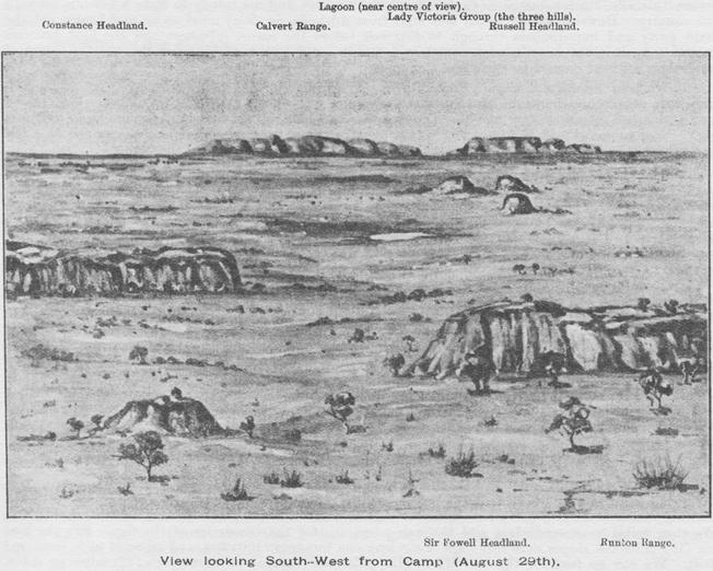
Sunday, August 30.--Leaving the small clay, pan at 6 a.m., we passed, at one (1) mile, through the gap in the range, which is half (1/2) a-mile on right of bearing. Then, bearing North 246deg. East for the lagoon seen yesterday, we crossed, at three and four (3 and 4) miles, the North end of a gypsum lagoon, which was dry, and about one (1) mile in extent. Travelling thence over lumpy porcupine and low sand-ridges, we found ourselves, at six (6) miles, out on an open, marshy flat, bearing samphire and a little salt bush. This extends Southerly towards the headland, and apparently right up to the large, bold, bluff hill in the range to the Northward. It was quite a relief to get clear of the sandridges and porcupine, even for a few miles.
At nine (9) miles we reached the supposed water, but found it to be a small, dry, salt lake bed, with small, salt watercourses coining in from the South and North-North-East. Then, continuing our journey North 241deg. East for the point seen in range on the 29th inst., we soon found ourselves in sandridges again. At eleven (11) miles another flat of saltbush and samphire occurred, extending towards the group of three prominent hills on our right. From here, on to fifteen (15) miles, we noted good class of wattle-bush in the troughs between the ridges, but after that not a vestige that camels would eat. We were now almost hemmed in by enormous drift sandridges, very steep, and almost insurmountable. They extended very nearly to the foot of the range, becoming more and more irregular and jumbled as we approached it. The camels knocked up, and we had a difficult task to get them along. We found no feed until we got right under the range itself, which we reached at 4 p.m., having travelled twenty-four (24) miles for the day. Here we found excellent soft, green herbage, and formed our camp one (1) mile North-West from the point of observation from yesterday's camp. This range (Calvert Range), which is about thirteen (13) miles direct from the salt lake visited this morning, is five hundred (500) feet higher in elevation, although now only one hundred and thirty (130) feet above its visible base. It is of sandstone, capped with quartzite rock.
Monday, August 31.—Mr. Jones and I walked about two (2) miles on foot last evening, following up a rough creek into the range, and then climbing to the summit, but we found no water. Finding the herbage so luxuriant, though small in extent, I decided to camp here to-day and give the weary camels a rest. After breakfast Mr. Jones accompanied me to the North-West in search of water. Following the foot of the range we noticed, at about one (1) mile, some green trees on the cliffs. They turned out to be small, white gums, growing from the crevices in the cliff rocks, without any visible soil. These are the first gum trees of this species (eucalyptus redunca) seen since we left depot. We were disappointed in finding no water here, but noticed some finches and cockatoos ten (10) chains further along the range at the foot of which were two (2) more small gum trees. Here I found a cave, and seeing finches fly out as I approached, we went in and found a soakage of fresh water resting in shallow basins on slabs of sandstone rock, some of which are very large and weigh many tons. Whilst Mr. Jones took some photographs and made copies of native rock-drawings, I ascended the range and took bearings to fix the positions of several of the prominent points seen on the 29th inst. Also noted from here a range about twenty-five (25) miles to the North-West, with another about midway. Along the range to the North-West a very prominent bold headland, with sheer face, is visible, about four (4) miles distant. This I have named "Russell Headland," after Mr. J. G. Russell, Commissioner of Taxes and Insolvency for South Australia.
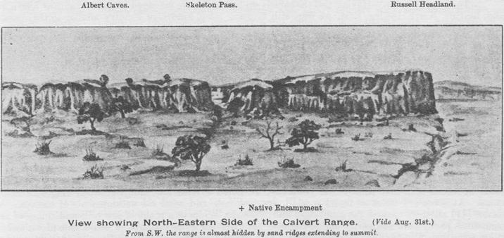
Returning to camp, we arranged for Bejah to bring the camels round to the cave for the water it which we found but a limited supply, getting only about six (6) gallons apiece for the thirsty animals. The soakage comes from the range through the enormous slabs of sandstone, and resting in the shallow basins until it overflows, disappears in rocky ground at the foot of the range. The supply is small, and may not last for longer than two or three (2 or 3) months after rain. I marked one of the two gum trees at the entrance of the cave thus:—L.A.W.3 inside diamond blaze. The range, which I have named after the promoter of this expedition, is partially mulga-clothed, and is scarcely visible from the South side being hidden by drift sandridges, which extend to its summit. Bejah returned to camp with the camels whilst Mr. Jones and I walked along the range towards the bold headland to get a photograph of it. At one (1) mile we passed a gap or pass extending through the range to the Southward. Here we noted the "ficus" growing from the rocks and near the entrance found an old native encampment.
We were surprised to find here the skeleton of a human being, in a hollow scraped out in the sand, with old dry boughs pushed into the ground, presumably to form a shade. The bones and skull were bleached, the latter being perfect except for one (1) missing tooth, which we found afterwards. I suppose this to be the skeleton of an aboriginal, but it is the first instance in which I have known natives to leave their dead without burial of some kind. It is possible that, the water failing the natives may have been compelled to go away, leaving an invalid behind. Mr. Jones took possession of the skull for scientific purposes. We returned to camp, having walked eleven (11) miles to-day, in spite of the loose sand, which makes walking difficult. We saw two (2) kangaroos this afternoon but were unable to get a shot at them. Found latitude, by observation at camp, 23deg. 58min. 55sec. South.
Tuesday, Sept. 1.—The camels having improved vastly in appearance whilst on the good feed, we start at 6-30 a.m., following North-Westerly along the foot of the range to the gap seen yesterday which I have named " Skeleton Pass," and bearing thence North 246deg. East over sandridges and porcupine, with a few sandstone outcrops. We cleared the range at five (5) miles from camp, and at eleven (11) miles passed close by another mulga-clothed hill on our right. Then came jumbles of sandridges and lumpy porcupine flats, with native poplars, a few desert gums, and quandong, until at seventeen miles, we camped on a small patch of fair feed. Latitude, 24deg. 3min. 16sec. South.
Wednesday, Sept. 2.—We allowed the camels to go loose all night, as they were not in want of water. Started at 6.20 a.m., still on same course. Plodding along on foot, a practice we have pursued throughout this trip for the first nine (9) miles of each day's journey, we found the sandridges as difficult cross as ever. At six (6) miles, altered course to North 221deg. East for a low, mulga-crowned ridge here onward we had limestone in the flats and porcupine in the flats and on the sandridges as usual; also native poplar, mallee, quandong, tall tea-tree, some desert gums, and grass trees (xanthorrhoea). The sandridges mounted higher and higher, reaching the very summit of the sandstone ridge, which we reached at fourteen (14) miles. We were now near Mr. Ernest Giles' route from the Murchison River to the Musgrave Ranges. To the Southward of this ridge were small samphire flats or marshes, and dwarf tea-tree. The view was not promising from here. To the South-West were two (2) low, flat-topped hills, about five and ten (5 and 10) miles distant; I have named these "Trainor Hills," after James Trainor, a member of this Expedition. A low point of another ridge bears North 193deg. East, with sandridges intervening. We altered our course to this bearing and continued onward for six (6) miles again, noting limestone outcropping in the flats. Natives had evidently not been in this part of the country for a long period, as the signs which usually betoken their presence were entirely absent. Noticed two (2) species of porcupine wallabies to-day and numbers of them started from their lairs as we moved along. Travelled for day about twenty (20) miles.
(Edited break in narrative)
(Main party heading north)
Saturday, Oct. 3.--Breakfast at 3.15 a.m., afterwards bearing North 290 deg. East for some high sandridges seen yesterday. Ascended two very high ridges at five (5) miles and six (6) miles respectively, but only to meet with the same horrible outlook and no indication of water. Saw low. mulga-clothed ridges to the West and North-West, two (2) or three (3) miles distant, and countless glaring red sandridges in all directions. Altered course, now bearing North 55deg. E. over sandridges and porcupine, with clumps of tall tea-tree in the flats or troughs between the sandridges. From four (4) to five (5) miles on this course we saw some good wattle-bush (acacia) ---the first feed seen since leaving our companions. Then altering course to North 355deg. East we travelled on for four (4) miles, again in country destitute of feed. Low mulga-clad sandstone ridges were visible to the Eastward, about six (6) miles distant, and another crowned with drift sand, two (2) miles to North-East. More glaring red sandridges to the North. From this point I noted a gully to the West with tall tea-tree and other green foliage which I took to be wattle-bush. This, together with the discovery of some very old native tracks, just visible in the sandy flats and going in the direction of the foliage, determined me to proceed to the latter and camp. Bearing North 250deg. East we camped, at one and a half (1 1/2) miles on the South edge of the gully. We had but little breeze during the morning, and it is now oppressively hot_ Starting, I proceeded South and after going a couple of hundred yards picked up the tracks, which were going South-Westerly. Following them, with difficulty, for half (1/2) a mile, we came to a small clump of desert gums (eucalyptus), and noticed that almost every tree had had, at some time or other, a piece of bark removed from the trunk—no doubt to make a dish or " coolamin " for the purposes of carrying water and food. To the Westward was a low flat with tea-tree, and a very small, bare flat was also visible to Bejah who kept this information to himself. I went for the tea-tree, regardless of tracks, whilst Bejah evidently made straight for the flat, which he reached before I did, but seeing some finches on its North side he made for that spot, whilst I discovered the water on the South side, which is one (1) mile W.S.W. of our camping-place. This water is perfectly fresh and soft. It is in a small well (Separation Well), in soft sandstone rock a few feet from the surface. No other stone is visible in the vicinity. There is a nice patch of half-green herbage (roly-poly or buckbush) immediately around the well for a few chains, also a quantity of wattle-bush. The growth of the former is no doubt owing to the numbers of old native encampments, which can be traced by the charcoal that is lying about in all directions. The discovery of water and feed together seemed to give us fresh energy, and we at once returned to camp and brought our packs and camels over. Watering our thirsty animals we soon had the hole forked, as it was but a small one, only large enough to allow us to get a billy-can to the bottom of it. The rock was four (4) feet from the surface, and the natives have apparently sunk three (3) or four (4) feet through this. I could see the water coming in from or under the rock, after removing about three (3) feet of debris consisting of small bones, bark, sticks, and decayed vegetation, which is to be found in all these native wells, when not in use.
I have noted that immediately around this well, and also at Midway Well, the growth of tea-tree is stunted, whilst further off it is tall and greener, which might lead one to suppose that the water would be found where the growth is most prolific. But this may be accounted for by the fact that the sand or soil is much shallower at the wells than where the larger timber exists. Although the water is green at present we each drank a considerable quantity of it, as we were very thirsty after being on allowance of the brackish water. A large number of crested and bronzewing pigeons and a fair number of galahs and flocks of shell parrots are coming here to water; this induces me to believe in its permanency. We bagged sixteen (16) pigeons. Travelled for day, with camels, eighteen (18) miles. I make the latitude of this spot, 22deg. 51min. 14sec. South, and East longitude about 123 deg 52min. It is now my intention to return to depot at Midway Well and bring the caravan and the rest of the party through to this water. We will then continue our course for Joanna Spring, and I can see that there must be no delay, owing to the lateness of the season. In so terrible a country as this, where glaring red sandridges, all trending almost at right angles to our course, present themselves a the view in every quarter, and where camel feed and water are scarce and the heat of the sand is intense, it is extremely difficult to proceed at this time of the year. The position of Joanna Spring is am about one hundred and ninety (190) miles from here, and with care and an ordinary run of luck I expect to get all camels and impedimenta through with safety. (Note; Separation Well is about 40 km south east of Well 27 on the Canning Stock Route. It is here that Charles Wells and George Jones separated from the main party and headed north west while his cousin Lawrence Wells and the main party headed due north towards Warburton's Joanna Spring about 300 km distant. Sadly Charles Wells and Gorge Jones
Sunday, Oct. 4.—Let camels go to feed until 7 a.m. this morning, and starting at 8 a.m., bearing North 170deg. East, we crossed our zigzag route of yesterday morning at seven (7) miles. Then bearing South-Easterly we cut our outward pads again, and camped at eighteen (18) miles without feed which however, we did not expect to find. To-day was very trying and cloudy, and this evening a closeness prevails. Innumerable small insects and ants are swarming around us and giving us a lively time.
Monday, Oct. 5. ---Selecting the best route for the caravan to take when it came up we proceeded direct for depot, which we reached at twenty (20) miles. Found all well and the camels much improved for the rest they have had. The well has been freely used, and the supply of water appears, as at first, undiminished. The variation of the needle, here, 41min. 20sec. East. During my absence the seed of the date palm has been planted at, and around, the well, and where tall tea-tree grows to the East-North-East. I believe these spots are favourable for planting.
Tuesday, Oct. 6.-I purpose giving the two (2) camels used by Bejah and self a rest here, to-day. Occupied in plotting and preparing for a start to-morrow. Had all kegs freshly filled with water. A large number of pigeons have been shot during the party's stay here, and we shall not now require all the tinned meat we have, in stock.
Wednesday, Oct. 7.—Started at 6.40 a.m. Taking all kegs and bags full of water we travelled eighteen miles, and camped at 2.30 p.m. The weather was excessively hot and trying, especially whilst crossing the sandridges after 11 a.m. During the evening walked about a mile East of camp to an outcrop or bar of sandstone, with ironstone cap, extending North and South, the sandridges crossing it Found native soakage well (dry), also bank and small drain for conserving the water. Discovered a little herbage beyond this spot, walking in all three miles.
Thursday, Oct. 8.—This morning we left at 4.20 a.m., following chiefly along my pad till my camping-place of the 2nd inst. was reached, then bearing North 327deg. East we reached the well at 1.34 p.m., at twenty (20) miles. The sandridges were steep and numerous, and owing to this and the heat of the afternoon the camels kept breaking their nose-lines during the latter part of the stage._ The sand becomes so hot after 11 a.m. that the poor brutes can barely endure walking over it. During the afternoon we cleaned out the well, removing all the accumulated rubbish, chipping off some of the soft sandstone rock at bottom and enlarging the hole, the well being then about ten (10) feet deep. We found we had a well of most delicious fresh water of excellent supply coming in from the sandstone near the bottom; the good quality renders it a great boon to us. The water in the last well is good for domestic use, but contains half an ounce of salt to the gallon, and is not, therefore, desirable for travelling on when one is on a daily allowance. There are sandstone elevations from four (4) to six (6) miles East and West from this spot, which probably dip towards it, forming a basin. If not, as I think, of a permanent character, this well has a large supply for a considerable length of time after rainfall.
Friday, Oct. 9.—We have now managed to water all the camels, and fill all kegs with fresh supply (300 gallons) and the well still justifies our good opinion of it. It rose to its original height during the night, and this morning it showed five (5) feet of water and a holding capacity of two hundred (200) gallons. The feed is good here, and, as I anticipate some difficulty in this respect when we continue our travels, I propose giving the camels today and tomorrow on it. Marked the only tea-tree growing in this little patch—which is about (2) chains North of the well: LAW 5. Again observed for latitude (mean) 22deg. 51min. 14sec.
Saturday, Oct. 10.—To-day the weather is working up for a thunderstorm. Early this morning I walked northward for two (2) miles, to find the easiest route for the camels when leaving here. We have been feasting on pigeons at this little oasis. Birds have been flocking here in great numbers for water, and shooting is as simple as robbing a hen-roost. These welcome little spots around the only three (3) wells of value hitherto discovered are, in this wretched country, truly oases and the only places of rest for man and beast. Herbage and bushes suited for camels surround each of the waters for short distances, thus enabling the traveller to refresh his weary "ships of the desert" with water and food; and it is on such occasions as these that one realises the value of water. In Australia its absence is frequently the only danger of importance that the explorer has to encounter. The seed of the date-palm has been freely planted around the well, to-day, and everything made ready for a start, to morrow. My cousin and Mr. Jones will leave us, here, for a trip to the North-West, and we hope to meet eventually, somewhere in the vicinity of Joanna Spring. They purpose proceeding along the flats or troughs between the sandridges, generally bearing North 290deg. East to North 300deg. East for eighty (80) miles, or even one hundred (100) should my cousin consider it advisable to go so far, and then in a North- Easterly direction to cut the route I purpose taking, a point thirty (30) or forty (40) miles South of Joanna Spring. I anticipate reaching this point in about twelve days, whilst my cousin, taking into consideration that the first eighty (80) or one hundred (100) miles can be done by him without crossing the sandridges, estimates that he will arrive at that point in about fourteen (14) days. In the event of not cutting our tracks, where he expects, he will continue on for Joanna Spring. Failing to find this, they will continue on, without loss of time, for the Fitzroy, in a North-North-Easterly direction. But in the event of finding Joanna Spring or any waters in that vicinity they will wait and signal for us, but only so long as their supplies of food will permit. They will take three (3) camels, sixty (60) gallons of water in two (2) pairs of kegs and their filled water-bags ; also provisions for a mouth and light equipment with necessary plans, etc. We are leaving a pair of ration cases here, and have buried 50lbs. of tinned meat near the marked tree at camp. (Charles Wells and George Jones perished about 25 km from Joanna Spring around 21 November 1896 and their bodies were recovered on 27 May 1897 by search party under LA Wells and Sub-Inspector Craven Ord; LA Wells had previously made several other unsuccessful search attempts. During one of these earlier searches LA Wells located Joanna Spring and established it was 24 km east of Warburton's plotted position.)
Sunday, Oct. 11.—We experienced thunderstorms all round us last night, but only a few drops of rain fell here. I am hoping that some of the showers fell to the Northward. Each party started from well at 7.15 a.m., Charles on a bearing of North 290deg. East, whilst our course was North 356deg. E. For the first eight (8) miles the sandridges were numerous, with loose sandy flats, dense porcupine desert gums, fair wattlebush and patches of waterbush occurring, and travertine limestone outcropping in places. Noted sandstone outcropping three (3) or four (4) miles distant to East and crossed some in the flats. Then followed wider flats until, at fourteen (14) miles, we reached a higher elevation of sand overlying sandstone, the higher points of the latter being one (1) mile to Eastward. (Read bearing North 313deg. East to a remarkable hillock of sandstone (Thring Rock) about four (4) miles distant.) We camped at this point in a mulga belt. To the North is a rather wide porcupine flat which will be of service to-morrow. Very poor feed here.
Monday, Oct. 12. —Started at 4.45 a.m. Following same course we crossed the flat at three and a half (3 1/2) miles, then more sandridges and porcupine. At seven (7) miles sighted a small but conspicuous hill to Eastward, one (1) mile distant, and South of that again another rise. I have named the hill after Mr. Stephen King, of the South Australian Survey Department, who was a member of John McDouall Stuart's Expedition across the Continent. Noticed outcrops of sandstone half a mile to West. Proceeding to them I found some very small rock-holes which were dry. From this elevation I saw a dry salt lake about three (3) miles to the North-West, situated in a valley which apparently extended some distance to the Eastward, the valley appeared to be dark and low with vegetation. Continuing on over numerous and rather steep sandridges we passed a patch of slate outcropping with a little loose quartz and prickly acacia bushes, which are rare in this country. The slate and quartz were also a surprise to me. At ten (10) miles we reached the edge of the -valley, and here saw good wattle-bush (acacia) tea-tree, mallee, quondong and porcupine. Many ridges and blows of travertine limestone were visible here. In the same valley, at twelve (12) miles, we crossed a shallow watercourse trending towards the lagoon also gypseous soil and outcrops. Enormous clumps of porcupine occurred here and onward. At fifteen (15) miles we reached the North side of the valley which is about 1,150 feet above sea level, the sandstone outcrops, from which the lake was seen, having an elevation of two hundred and fifty (250) feet. In the flats, on either side of this valley, are large ant-hills up to eight (8) feet high. Being afraid to pass this feed I determined to camp here at 11.15 a.m. I am of opinion that water would be found in this valley at moderate depths. Saw some crows here and, just before entering the valley, tracks of natives were seen. High drift sandridges are visible to the North of camp, and from the summit of one of these, a mile from camp, the lake was plainly visible, bearing North 245deg. East, and about two (2) miles distant. I have named it after Mr. W. P. Auld, of Adelaide, who was a member of Stuart's famous Expedition. At two (2) miles from camp, whither I had walked in search of water, I could see high red sandridges in all directions for a considerable distance, and about two (2) miles west, some sandstone outcrops. Travertine limestone exists, also, on this side of the valley. Latitude by observation, 20deg. 24min. 48sec. South, at camp. The same disheartening outlook everywhere! Although there is no doubt that something fairer to look upon existed here before this terrible sand hid it from view. (Thring Rock and King Hill are on the Canning Stock Route about 40 km or so north of Well 28. When heading north, LA Wells' party was unable to locate Joanna Spring and being desperate for water headed directly to the Fitzroy River over 100km away. Charles Wells and Jones also desperate for water came upon the main party's tracks south of Joanna Spring and followed then expecting they would lead to water.)
Sources (text and picture extracted from): Wells, LA: Journal of the Calvert Scientific Exploring Expedition, 1896-97, Wn Alfred Watson, Government Printer, Perth, 1902. Facsimile edition, Hesperian Press, Victoria Park, 1993.
Doubts over picture captioning arise from Calvert pictures in: Blackburn, Geoff: Calvert's Golden West, Hesperian Press, Victoria Park, 1997, page xi. And from: Cannon, Michael: The Exploration of Australia, Readers Digest Sydney, 1987, page 260.
In 1896-1897, the Hon. David Wynford Carnegie, born in 1871, youngest son of the Earl of Southesk, led one of the last great expeditions in the exploration of Australia. His route from Lake Darlôt to Halls Creek and return, took thirteen months and covered over three thousand miles. Carnegie financed his expedition from the results of a successful gold strike at Lake Darlôt. David Carnegie returned to England in 1898 and was awarded a medal by the Royal Geographic Society. In 1899 he was appointed Assistant Resident and Magistrate in Northern Nigeria. On 27 November 1900 while on an expedition to capture a brigand he was shot in the thigh with a poisoned arrow and died minutes later. He is buried at Lokaja, Nigeria and a memorial to his memory is in St. George's Cathedral, Perth.
The following extract from Carnegie's narrative has been extensively truncated to remove descriptive details for reasons of economy in overall document length.
Edited extract only from:
SPINIFEX AND SAND
A Narrative of Five Years' Pioneering and Exploration in Western Australia
By The
HON. DAVID W CARNEGIE (1871-1900)
Illustration 1: David W. Carnegie.
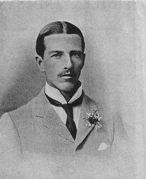
To MY MOTHER
1896
A few days' rest and feed, fortunately soon puts a camel right, and such they could have at the little oasis we had reached on October 5th. In the centre of it lay a splendid little spring, in many ways the most remarkable feature we had encountered, and therefore I christened it after one whose love and helpful sympathy in all my work, has given me strength and courage—my sister Helena. (Helena Spring is about 85 km east of No 42 Water Guli on the Canning Stock Route.)
CHAPTER XII Helena Spring
My native valley hath a thousand springs, but not to one of them shall I attach hereafter, such precious recollections as to this solitary fount, which bestows its liquid treasures where they are not only delightful, but nearly indispensable.
So spake Sir Kenneth of Scotland in The Talisman.
Surely the Christian knight, dragging his way across the sands of Palestine, was not more pleased to reach the “Diamond of the Desert” than we were to light upon this charming little oasis, hidden away in the dreary solitude of the surrounding sandhills; the one spot of green on which one's eyes may rest with pleasure in all this naked wilderness. At the bottom of a hollow enclosed between two sand-ridges is a small surface outcrop of limestone of similar character to that in which Empress Spring is situated. In this is a little basin, nearly circular, about 2 feet 6 inches in diameter and 3 feet deep, with a capacity of about seventy gallons. This is the spring, fed at the bottom of the basin from some subterranean source by a narrow tunnel in the rock, a natural drain, not six inches in diameter. Through this passage, from the West, the water rises, filling the rocky basin, and evidently at some seasons bubbling over and filling the clay-pan which abuts on it on the Western side. On the East side of the spring is an open space of sand; surrounding it and the clay-pan is a luxuriant growth of pig-face—a finger-like plant, soft, squashy, and full of moisture, but salt; it is commonly seen on the margin of salt-lakes. Beyond the pig-face, tussocks of grass and buck-bush, beyond that again a mass of ti-tree scrub extending to the foot of the sandhills. On the inner slopes of these can be seen the crowning glory of the spot viz., an abundance of splendid green thistle (Trichodesma zeylanicum), tall and juicy, growing amongst acacia and other bushes. Outside this, beyond this area of perhaps four hundred yards in diameter, stretching away to the horizon, ridge upon ridge of desolate sand, black and begrimed by the ashes of recently burnt spinifex, from which the charred stumps of occasional gum trees point branchless to the sky. What chance of finding such a place without the help of those natives to whom alone its existence was known?
The winds and storms of past years had filled in the basin with sand and leaves, and except for the extraordinary freshness and abundance of vegetation around it, its peculiar situation, and the absence of the usual accompaniments to rock-holes, such as heaps of sticks and stones which, having served their purpose of protecting the water from evaporation, have been removed and thrown aside by the natives, there was nothing at first sight to lead one to suppose that any further supply existed than was visible in this natural reservoir. This small amount soon vanished down the throats of the thirsty camels; it was then that, having cleared out the sand and leaves, we discovered the small passage through which the spring rises. By continual baling until all the camels were satisfied (and of this splendid spring water they drank a more than ordinary amount) we kept the water back to the mouth of the passage. Within an hour or so of the watering of the last camel, the hole was again full to the brim, of the most crystal-clear water. How we revelled in it! What baths we had—the first since we left Woodhouse Lagoon over seven weeks back! What a joy this was, those only can understand who, like us, have been for weeks with no better wash than a mouthful of water squirted into the hands and so rubbed over the face. Whenever possible Godfrey, who made our damper (bread), washed his hands in the corner of a dish, which was used by each in turn afterwards—and at our work in the wells, a certain amount of dirt was washed off. But to splash about with an unlimited number of buckets of water ready to hand, to be got by the simple dipping of a billy-can—this was joy indeed! This luxury we enjoyed from October 5th to October 10th, and every day the camels were brought to water, and with this and the green feed visibly fattened before our eyes.
So soon as we had proved the supply of our new watering-place, I had intended giving our guide his liberty. However, he forestalled this by cleverly making his escape. For want of a tree, his chain had been secured to the iron ring of a heavy pack-bag. His food and water were given him in empty meat-tins. With the sharp edge of one of these he had worked so industriously during the night that by morning he had a neat little circle of leather cut out of the bag round the ring. With a blanket on which he had been lying, he covered his cunning trick and awaited his opportunity. It soon came; when our attention was fixed on the building of a shade, and, in broad daylight, he sneaked away from us without a sign or sound, taking with him some three feet of light chain on his ankle. What a hero he must be thought by his fellow-tribesmen and doubtless that chain, which he could easily break on a stone with an iron tomahawk, will be treasured for many years to come. Had he not been in such a hurry he would have returned to his family laden with presents, for we had set aside several articles designed for him.
Our camp was specially built to protect us from the flies, and consisted of a framework of ti-tree poles and branches, roofed with grass and pig-face; under this we slung our mosquito-nets and enjoyed perfect peace. A few days in camp are by no means idle ones, for numerous are the jobs to be done—washing and mending clothes, patching up boots and hats, hair cutting, diary writing, plotting our course, arranging photograph plates (the majority of which were, alas! spoilt by the heat), mending a camera cracked by the sun, making hobble-straps, mending and stuffing saddles, rearranging packs cleaning firearms, and other like occupations. (detail edited)
CHAPTER XIII From Helena Spring To The Southesk Tablelands.
On October 11th we reluctantly left the “Diamond of the Desert” behind us, travelling in a N.E. by N. direction over the interminable sand-ridges, crossing a greater extent of burnt country than we had yet seen, and finally camping on the top of a high ridge so as to catch any breeze that the night might favour us with.
We made a long march that day of eighteen miles a very creditable stage in such peculiarly configurated country. The camels had so benefited by their rest and feed that it made little difference to them that they had nothing to eat that night; they were well content to lie round the camp all night and chew the cud. I have often noticed how much camels like society; under favourable conditions—that is to say when travelling in good camel-country like the Southern goldfields—they will feed for an hour or so before dark, then slowly make their way with clattering hobble-chains and clanging bells back to the camp-fire, and there, with many grunts of satisfaction, lie peacefully until just before daylight, when they go off for another feed. On moonlight nights they like to roam about and pick choice morsels of bush on and off until daylight. In this waste corner of the earth where now we battled our way, the poor brutes wandered aimlessly about, now trying a mouthful of sharp spinifex and now the leaves of a eucalyptus; turning from these in disgust, a little patch of weed might be discovered by one lucky camel; no sooner would he hurry towards it than the others would notice it, and then a great scramble ensued and the weakest went without—though I have seen the strong help the weak, as in the case of Czar, who, with his powerful jaws, would break down branches for Misery, then quite young and without the requisite teeth. How fine they look with their long necks stretched upwards with the heads thrown back and the sensitive lips extended to catch some extra fresh bunch of leaves! How cunningly they go to work to break a branch that is out of reach; first the lowest leaf is gently taken in the lips and pulled down until the mouth can catch hold of some hanging twig—along this it is worked, and so from twig to branch, a greater strain being exerted as the branches increase in size, until finally the main limb of the branch is seized, and bent and twisted until broken. Often they try for one branch time after time, for having set their minds on a particular morsel, nothing will satisfy them until they have it.
No such scene could be watched from our camp on the ridge. But still we had something out of the common to look upon in the shape of hills ahead, and my hopes were high that we should soon see the last of the desert. Away to the North high points and bold headlands stood out black and clear above the sea of sand, tablelands and square-edged hills with some high peaks rising from them—the most imposing hills we had seen since passing Mount Burgess, near Coolgardie. From this point little could be determined as to their character even with glasses, for they were, as we afterwards found, over thirty miles distant.
Between them and our camp numerous low detached, table-top hills and conical mounds could be seen—none of any size, but remarkable in shape and appearance. These I named the Forebank Hills, after a hill near my home. These hills gave promise of better country, and, choosing a prominent headland, I altered our course towards it the following morning. We had not been travelling long before a smoke rose quite close to us, and we had another opportunity of seeing native hunting operations without being seen ourselves. A fine upstanding buck was dodging about amongst the blazing spinifex and was too engrossed to notice us; presently his occupation led him over the ridge and we saw him no more. From the earliness of the hour—for the smokes as a rule do not rise before 9 a.m.—it was clear that he could not have come far, so, picking up his tracks, we followed them back to his camp. Though we were not in great want of water, I considered it always advisable to let no chance of getting some slip by, since one never can tell how long the next may be in coming.
The tracks led us along the foot of one ridge; along the next, some three hundred yards distant, the ladies of the tribe could be seen marching along, laughing and chattering, and occasionally giving forth the peculiar shrill yell which only the gins can produce. It is impossible to describe a noise in writing, but the sound is not unlike a rather shrill siren, and the word shouted is a long-drawn “Yu-u-u.” There is no mistaking the women's voices, the men's cry is somewhat deeper. Both are rather weird sounds, more especially when heard in thick scrub where one can see no natives, though one hears them all round. In the spinifex they were easily seen, and to their cry an answering yell came over the ridge and other women and children appeared. Presently they saw our caravan, and the “Yu-u-u” became fainter and fainter as the group scattered in all directions, and was lost to view. At the end of the tracks we found a camp, and in it the only attempt at a roofed shelter that we saw in the desert, and this merely a few branches leant against a small tree. The camp-fire had spread and burnt the spinifex close by, which gave the spot anything but an inviting appearance. (detail edited)
He showed us their well, which was nearly dry, and then volunteered to lead us to others; and away he went, swaggering along and clicking his tongue in great glee, occasionally breaking out into shrieks of laughter. When we arrived at one dry rock-hole and then another, it dawned upon me what the secret joke had been that so amused our friend; and I determined that he should be of some use to us before we parted company. Of these dry rock-holes, one would, after rain, hold a fair amount of water, and is situated on the shoulder between two low table-tops. To the South, about two miles distant, are three conspicuous conical hills, close together, and about the same distance to the North-West a hill that at once calls to mind an old fort or castle. (detail edited)
Between the Forebank Hills and the tablelands we were now approaching is an open plain of spinifex some ten miles wide, bounded on North and South by sand-ridges. From these in the morning the long line of broken tablelands could be seen ahead of us, and running for a considerable distance to the eastward. The highest point of those more immediately to our front I named Mount Fothringham, after my cousin. The headland for which we were steering was too far off to be reached that night, so we camped on a ridge, and during the night noticed a small fire in the hills ahead. It could only be a camp-fire of some natives, so, noting its direction, and being unable to see anything further, we retired to rest.
The next morning, with the help of the glasses, we could see several black figures moving about on the sloping foot of the cliffs, and therefore steered in their direction. Our mad friend had to be accommodated on the top of a camel, as he refused to walk or move, and I wished to leave him with friends, or at any rate with fellow-countrymen, though we no longer required his services as guide, in which capacity he had been singularly useless. Five miles brought us to the hills, and close on to the natives' camp whose fire we had seen, before they discovered us; when they did so they fled, seven or eight of them, and hid in caves in the sandstone. We had now been only four days since the last water, but the weather was so hot, feed so scarce, and so much ground burnt and dusty, that it was time we gave the camels another drink if we wished to keep them in any sort of condition. From the native camp a few tracks led round a corner of rock; these I followed, with the camels coming behind, and soon saw two small native wells sunk in the sand and debris, held in a cleft in the rock. Nothing but bare rock rose all round, and on this we made camp, turning the camels out at the foot of the cliffs where a few bushes grew. (detail edited)
These natives showed no fear or surprise when once in the camp, and, examining our packs and saddles, sat “jabbering” away quite contented, until Breaden struck a match to light his pipe. This so alarmed them that they bolted. We did not attempt to stop the boy, but detained the man, as I wished for further information about waters, and was also anxious to study his habits. He had evidently been in touch with blacks from settled parts, for he knew the words, “white-fella” and “womany,” and had certainly heard of a rifle, for on my picking one up and holding it towards him he trembled with fear, and it was some time before his confidence in us was restored. He really was a most intelligent man, both amusing and interesting, and by signs and pantomime, repeated over and over again until he saw that we guessed his meaning, he told us many things. Plenty of women, old and young, were camped in one direction, and were specially worth a visit; he knew of several watering-places, in one of which we could bathe and stand waist-deep. So I made a compact that as soon as he showed us this wonderful “Yowie” (his word for water) he should go free. He seemed perfectly to understand this. Our mad friend he hardly deigned to notice, and pointed at him in a most contemptuous way.
Work (on digging out the wells) was carried on all night, which was divided as usual into shifts, and this I have no doubt saved us from attack. Before sunset we had seen several bucks sneaking about the rocks, and during the night they came round us and held a whispered conversation with their fellow in our camp. Between them a sort of telegraphy seemed to be going on by tapping stones on the rocks. They may have been merely showing their position in the darkness, or it is possible that they have a “Morse code” of their own. I was on shift when they came, and as the well wanted baling only every twenty minutes, I was lying awake and watching the whole performance, and could now and then see a shadowy figure in the darkness. As soon as I rose to work, our buck lay down and snored heavily, and his friends of course were silent. I awoke Breaden on my way, as it would have been far too much in their favour should the blacks have attacked us and found me down the well and the rest of the party asleep. (detail edited) The wells, situated as they are in the bed of a rocky gully, would after rain hold plenty of water, though we extracted no more than thirty-five gallons. Their position is lat. 20° 46´, long. 126° 23´.
From the rocks above the wells the tablelands to the East have quite a grand appearance, running in a curve with an abrupt cliff on the Western side, and many conical and peaked hills rising from their summit. These tablelands, which in a broken line were seen by us to extend Northwards for over forty miles, and certainly extend Eastwards for twenty miles and possibly a great deal further, are of sandstone. Looking Westwards, a few detached blocks may be seen, but we seemed to have struck the Western limit of these hills. I have named them the Southesk Tablelands, after my father. Between the curved line of cliffs and the wells are several isolated blocks. Seven and a half miles to the Westward a remarkable headland (Point Massie) can be seen at the Northern end of a detached tableland. Again to the West, one mile, at the head of a deep little rocky gorge, whose entrance is guarded by a large fig tree, is a very fine rock-hole. This was the promised water, and our native friend was free to return to his family; he was greatly pleased at the bargain being carried out, and had evidently not expected it. Possibly what he has heard of the white-fella is not much to his credit! The fig tree afforded a splendid shade from the burning sun, and in a recess in the rock close by we could sit in comparative coolness. Here the native artist had been at work, his favourite subject being snakes and concentric rings.
A steep gorge, not very easy for camels to pass along, led up to the rock-hole, which lies under a sheltering projection of rock. From the rock above a good view is obtained; sand-ridges to the West, to the North and East tablelands. Most noticeable are Mounts Elgin, Romilly, and Stewart, bearing from here 346°, 4°, 16° respectively. These hills are named after three of my brothers-in-law. They are of the usual form—that is to say, flat-topped with steep sides—Mount Elgin especially appearing like an enormous squared block above the horizon. To the South-East of Mount Stewart are two smaller table-tops close together. (Well 47 on the Canning Stock Route is about 20km to the west of Mount Romilly.)
As I walked over the rocks I noticed numerous wallabies, of which Godfrey shot several later; they were excellent eating, not unlike rabbit. Leaving the rock-hole, we steered for Mount Romilly, first following down the little creek from the gorge until it ran out into the sand in a clump of bloodwoods. Then crossing a plain where some grass grew as well as spinifex, we came again into sand-ridges, then another plain, then a large, dry clay-pan West of Mount Stewart, then more ridges up to the foot of Mount Romilly. It was here that we must have crossed the route of Colonel Warburton in 1873, though at the time I could not quite make out the relative positions of our two routes on the map.
Colonel Warburton, travelling from East to West, would be more or less always between two ridges of sand, and his view would therefore be very limited, and this would account for his not having marked hills on his chart, which are as large as any in the far interior of the Colony. In his journal, under date of September 2nd, we read:
…There are hills in sight; those towards the North look high and hopeful, but they are quite out of our course. Other detached, broken hills lie to the West, so our intention is to go towards them. Then, on September 3rd: N.W. by W. to a sandstone hill (probably Mount Romilly). North of us there is a rather good-looking range running East and West with a hopeful bluff at its Western end (probably Twin Head)... (Dates and comments here were added by Carnegie but Warburton's last note; North of us there etc was made on Sept 4 not 3 as Carnegie implies.)
From the top of Mount Romilly a very prominent headland can be seen bearing 7°, and beyond it two others so exactly similar in shape and size that we called them the Twins. For these we steered over the usual sand-ridges and small plains, on which a tree (Ventilago viminalis) new to us was noticed; here, too, was growing the Hibiscus Sturtii, whose pretty flowers reminded us that there were some things in the country nice to look upon. Near the foot of the second headland we made camp. Leaving Charlie behind, the rest of us set out in different directions to explore the hills. There are four distinct headlands jutting out from the tableland, which extends for many miles to the Eastward and in a broken line to the Southward, the face of the cliffs on the Western shore, so to speak, being indented with many bays and gulfs, and, to complete the simile, the waves of sand break upon the cliffs, while in the bays and gulfs there is smooth water—that is to say, flat sand. Grass and other herbage and bushes grow in a narrow belt around the foot of the cliffs, but everywhere else is spinifex.
The hills present a most desolate appearance, though somewhat remarkable; sheer cliffs stand on steep slopes of broken slabs and boulders of sandstone, reminding one of a quarry dump; from the flat summit of the cliffs rise conical peaks and round hills of most peculiar shape. The whole is covered with spinifex, a plant which seems to thrive in any kind of soil; this rock-spinifex, I noticed, contains much more resinous matter than the sand-spinifex, every spine being covered with a sticky juice. From our camp I walked up the valley between the first and second head, and, ascending the latter, which is crowned with cliffs some thirty feet high, sat down and examined the hills with my glasses. Two black objects moving about caught my eye, and as they approached I saw them to be two fine bucks decked out in most extravagant manner. From my point of vantage some three hundred feet above them, I could watch them, myself unseen. Each carried a sheaf of spears, woommera, and shield, and in their girdle of string a number of short throwing-sticks. Round their waists were hanging sporrans formed from tufts of hair, probably similar to those we found at Family Well that were made from the tufts from the ends of bandicoots' tails; their bodies were painted in fantastic patterns with white. Their hair was arranged in a bunch on the top of their heads, and in it were stuck bunches of emu feathers. Seen in those barren, dull-red hills, they looked strange and almost fiendish. They were evidently going to pay a visit to some neighbours either to hold festival or to fight—probably the latter.
When almost directly below they looked up and saw me; I remained quite still, watching all the time through the glasses. After the first surprise they held a hurried consultation and then fled; then another consultation, and back they came again, this time very warlike. With shouts and grunts they danced round in a circle, shaking their spears at me, and digging them into the ground, as much as to say, “That is what we would do to you if we could!” I rose from my hiding place and started to go down towards them, when they again retired, dancing and spear-waving at intervals. At the end of the valley, that is the third valley, there is a sheer cliff to a plateau running back to the foot of some round hills; across this plateau they ran until, on coming to some thick bushes, they hid, hoping, I have no doubt, to take me unawares. However, I was not their prospective victim, for no sooner had they planted themselves than I saw Godfrey, all unconscious, sauntering along towards them.
The whole scene was so clear to me from my lofty position that its laughable side could not help striking me, but this did not prevent my forestalling the blacks' murderous designs by a shot from my rifle, which was sufficiently well aimed to scare the bucks and attract Godfrey's attention. As soon as possible I joined him and explained my seemingly strange action. We tracked up the natives, and found they had been following a regular pad, which before long led us to a fine big rock-hole in the bed of a deep and rocky gully. A great flight of crows circling about a little distance off, made us sure that another pool existed; following down the first gully and turning to the left up another, deeper and broader, we found our surmise had been correct. Before us, at the foot of an overhanging rock, was a beautiful clear pool. What a glorious sight! We wasted no time in admiring it from a distance, and each in turn plunged into the cool water, whilst the other kept watch on the rocks above. Sheltered as it was from the sun, except for a short time during the day, this pool was as ice compared to the blazing, broiling heat overhead, and was indeed a luxury. By the side of the pool, under the overhanging rock, some natives had been camped, probably our friends the warriors; the ashes were still hot, and scattered about were the remains of a meal, feathers and bones of hawks and crows. Above the overhanging rock, in the middle of the gully, is a small rock-hole with most perfectly smooth sides, so situated that rain water running down the gully would first fill the rock-hole, and, overflowing, would fall some twenty feet into the pool below. The rock is of soft, yellowish-white sandstone. Close to the water edge I carved C96 and Godfrey scratched the initials of all of us. The pool, which when full would hold some forty thousand gallons, I named “Godfrey's Tank,” as he was the first white man to set eyes upon it.
(Near Well 48, the Canning Stock Route passes just to the west of Twin Heads, Godfrey's Tank and Breaden Pool.)
Having finished our bathe, we set about looking for a path by which to bring the camels for a drink; the gorge was too rocky and full of huge boulders to make its passage practicable, and it seemed as if we should have to make a detour of a good many miles before reaching the water. Fortunately this was unnecessary, for on meeting Breaden he told us he had found a small pool at the head of the first valley which was easy of access. This was good news, so we returned to camp, and, as it was now dark, did not move that night. And what a night it was!—so hot and oppressive that sleep was impossible. It was unpleasant enough to be roasted by day, but to be afterwards baked by night was still more so! A fierce fire, round which perhaps the warriors were dancing, lit up the rocks away beyond the headlands, the glow showing all the more brilliantly from the blackness of the sky.
The next morning we packed up and moved camp to the pool, passing up the first valley—Breaden Valley—with the first promontory on our left. At the mouth of the valley, on the south side, are three very noticeable points, the centre one being conical with a chimney-like block on one side, and flanking it on either hand table-topped hills.
Down the valley runs a deep but narrow creek which eventually finds its way round the foot of the headlands into a ti-tree-encircled red lagoon enclosed by sand-ridges. Near the head of the valley the creek splits; near the head of the left-hand branch is Godfrey's Tank; in the other, just before it emerges from the cliffs, is the small pool found by Breaden. Several kinds of trees new to me were growing in the valleys, one, a very pretty crimson-blossomed tree, not unlike a kurrajong in size, shape, and character of the wood, but with this difference, in leaf, that its leaves were divided into two points, whilst the kurrajong has three. One of these trees had been recently chopped down with a blunt implement, probably a stone tomahawk, and a half-finished piece of work—I think a shield—was lying close by. The wood is soft, and must be easily shaped. It is rather curious that the natives, of whom, judging from the smoke seen in all directions, there must be a fair number, should not have been camped at such a splendid water as Godfrey's Tank, the reason of their absence being, I suppose, that camping in the barren hills would entail a longish walk every day to any hunting grounds. To the native “enough is as good as a feast,” and a wretched little well as serviceable as a large pool. The nights were so cloudy that I was unable to see any stars, but by dead reckoning only the position of the pool is lat. 20° 15´ long. 126° 25´.
From the top of the highest headland, which is divided into two nipple-like peaks, an extensive view can be obtained. To the South and the South-East, the Southesk Tablelands; to the East, broken tablelands and sandhills; to the North, the same; to the North-West, nothing but hopeless ridge upon ridge of sand as far as the horizon. To the West, some ten miles distant, a line of cliffs running North and South, with sand-ridges beyond, and a plain of spinifex between; to the North of the cliffs an isolated table-top hill, showing out prominently—this I named Mount Cornish, after my old friend and tutor in days gone by.
Leaving the hills on the 21st, we soon reached a little colony of detached hills of queer shapes, one, as Breaden said, looking “like a clown's cap.” From the top of the highest, which I named Mount Ernest, after my brother-in-law, a dismal scene stretched before us, nothing but the interminable sand-ridges, the horizon as level as that of the ocean. What heartbreaking country, monotonous, lifeless, without interest, without excitement save when the stern necessity of finding water forced us to seek out the natives in their primitive camps! Every day, however, might bring forth some change, and, dismal as the country is, one was buoyed up by the thought of difficulties overcome, and that each day's march disclosed so much more of the nature of a region hitherto untraversed. It would have been preferable to have found good country, for not only would that have been of some practical benefit to the world at large, but would have been more pleasant to travel through. So far we had had nothing but hard work, and as the only result the clear proof that a howling wilderness of sand occupies the greater area of the Colony's interior. (The Canning Stock Route passes close by the southern base of Mount Ernest.)
By going due East from Mount Ernest I could have cut the Sturt Creek in less than one hundred miles' travel, which would have simplified our journey. But taking into consideration that an equal distance would probably take us beyond the northern boundary of the desert, I determined to continue on a Northerly course, as by doing so we should be still traversing unknown country, until we reached the Margaret River or some tributary of it; whereas by cutting and then following up the Sturt, we should merely be going over ground already covered by Gregory's and subsequent parties.
Careful scanning of the horizon from Mount Ernest resulted in sighting some hills or rocks to the North-East. Excepting that higher ground existed, nothing could be seen as to its nature, for it was ever moving this way and that in the shimmering haze of heat and glare of the sun, which, intensified by powerful field-glasses, made one's eyes ache. I find it hard indeed to render this narrative interesting, for every page of my diary shows an entry no less monotonous than the following:—
Same miserable country—roasting sun—no feed for camels—camp on crest of high ridge in hopes of getting a breath of air—thousands of small ants worry us at night—have to shift blankets half a dozen times. Val's feet getting better—she can again walk a little.
The high ground seen from Mount Ernest turned out to be bare rocks of black ironstone, from which we sighted a very large smoke rising to the eastward—miles of country must have been burning, a greater extent than we had yet seen actually alight. Probably the hot weather accounted for the spread of the flames. Though apparently at no great distance, it took us all that day and six hours of the next to reach the scene of the fire, where spinifex and trees were still smouldering and occasionally breaking into flames, whirlwinds of dust and ashes rising in every direction. Having camped we set out as usual to find tracks, Breaden and Warri being successful in finding a pad of some dozen blacks going in the same direction. This they followed for a few miles, and returned long after dark, guided by a blazing bank of spinifex; very worn and thirsty they were too, for tramping about in sand and ashes is a most droughty job. (detail edited)
I noticed a considerable change in the country to the East, over which there spread a forest of desert oak, and near the sandhills thickets of ti-tree. The well seems to be at the head of an ill-defined watercourse, which, lower down, runs between an avenue of bloodwoods. Close to the well are several large ant-heaps, and from the sandhill above it little can be seen; but north of the well one mile distant is a high ridge of sand, from which is visible a prominent square hill, bearing 334° distant eighteen miles; this stands at the Eastern end of a tableland, and is named Mount Bannerman, after my sister-in-law. The well had an abundant supply, though a little hard to get at, as it was enclosed by two rocks very close together, necessitating a most cramped position when baling with a saucepan on the end of a stick.
By daylight we had watered all the camels and were glad to rest under the shade we had made with boughs. Our rest lasted three days to allow Prempeh, who was very poorly, to recover. The flies, as usual, worried us unmercifully, but I was so thankful to regain once more my sense of hearing that I rather enjoyed their buzzing. I had for some weeks been so deaf that unless I had my attention fixed on something, I could not hear at all. I must have been a great bore to my companions very often, for frequently they talked for a long time to me, only to find that I had not heard a word!
We were greatly entertained by two small boys, the sole representatives of the tribe, who showed intense delight and interest in all our doings, and were soon tremendous chums with Warri. One was quite a child, very sharp and clever; the other a young warrior, very proud of his spear and shield—a well-built youngster whose appearance was somewhat spoiled by a severe squint in one eye. They showed no fear whatever of us, or of the camels, and were soon on quite friendly terms with the latter, patting and stroking their noses; they lost confidence before long, when the small boy inadvertently patted the wrong end of a camel and was kicked violently.
The position of the Jew Well is lat. 19° 41´, long. 127° 17´; from it we steered to Mount Bannerman, over the usual ridges of sand, now further apart and lower. On some of the flats between we found splendid little patches of feed (amongst it Goodenia Ramelii), where the spinifex had been burnt and was just sprouting up again. One plant, new to us, was growing in profusion and resembled nothing so much as bunches of grapes with the fruit pulled off. We camped early, as such feed was not to be passed by. The next morning, we found that our axe had been left behind at the well; so, as it was a most useful article, I sent Warri back for it, whilst Godfrey and I put in the day by following the young warrior, who volunteered to show us a very large water—a ten-mile walk with nothing at the end of it was not at all satisfactory, nor did we feel very kindly disposed to our small friend. I suppose he wanted to find his tribe again, for when we stopped we could see a smoke in the distance.
We saw quite a number of spinifex rats, and though Godfrey carried a gun one way and I carried it coming home, we never bagged one, and only had one shot, which missed. Every rat got up quite 150 yards off in the most annoying way. We started burning a patch of spinifex, but since we were not pressed for food we concluded that the weather was quite hot enough without making fires! I fancy that only by taking a leaf out of the blackfellows' book could one have any success in spinifex-rat hunting. I have read in Giles's book, and Sir John Forrest has told me, that when he was in the bush the rats were easily secured. Possibly they were more numerous in the better country that he passed through, or larger and not so quick. All our efforts were unavailing, the only occasion on which we slaughtered a rat being when Val caught a young one; the full-grown ones were far too fast for her and too quick in turning round the hummocks of spinifex.
Warri returned with the axe in the evening and reported that no natives had visited the well since our departure. The next day as we approached the hills the two boys, sitting aloft on the top of the loaded camels, were much excited and made many signs that water was not far off. The hills we found to be the usual barren, rocky tablelands, scoured into gullies and gorges, which, forming small creeks, disappear before many miles amongst the sandhills.
Mount Bannerman stands at the eastern end of the hills; a little to the west is a deep and narrow gorge, the bed of which is strewn with great boulders and slabs of rock. The hill is capped with a conglomerate of quartz, sandstone and ironstone pebbles, some of the quartz fragments being as large as hen's eggs and polished quite smooth. From its summit an apparently high range can be seen to the North; to the East and South nothing but sand-ridges; to the South-West a prominent square hill, the highest point in a broken table-range, bears 226°. This hill I named Mount Erskine, after the Kennedy-Erskines of Dun.
Source: Carnegie, David W Hon, Spinifex and Sand: A Narrative of Five Years Pioneering and Exploration in Western Australia, C Arthur Pearson Limited, London, 1898. Downloaded during April- May 2009 from Journals of Australian Land and Sea Explorers and Discoverer; Project Gutenberg Australia e-books accessed at http://gutenberg.net.au/explorers-journals.html (To fit economically into this document some minor format and font changes have been made.)
Extract only from:
DO NOT YIELD TO DESPAIR
Frank Hugh Hann's Exploration Diaries in the Arid Centre of Australia
Compiled and Edited by
MIKE DONALDSON and IAN ELLIOT
Hesperian Press Victoria Park 1998
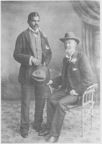
Talbot and Frank Hann
Frank Hugh Hann was born on in Wiltshire England on 19 October 1846. His family first settled in Westernport Victoria but moved to Queensland in the 1860s. He managed Lolworth station in 1865-70. In 1875, he took up Lawn Hill station in the Gulf country but was overtaken by low prices, poor seasons and the outbreak of redwater fever. He walked off the station in 1894. Penniless and very miserable he overlanded to Western Australia with 6 Aboriginals and 67 horses in 1896. He searched in vain for suitable country in the Nullagine district and in 1897 decided to return to Queensland but was diverted to a short-lived gold rush at Mount Broome in the West Kimberley district. In the winter of 1898 he penetrated the King Leopold Ranges, until then a barrier to expansion, discovered and named the Charnley and Isdell Rivers and located some fine areas of pastoral country. This feat of bushmanship and endurance was remarkable for Hann was over 50 and suffering from the after-effects of a broken thigh and the area he traversed was one of the most difficult in Australia and peopled by unwelcoming Aboriginals. He took up over 1000 square miles of the new country he had discovered. However, he had no funds to buy stock and it was pioneered by established Kimberley families. Hann lived in Perth for four years and then turned to prospecting. Authorized by the Western Australian government to explore the inland desert, he opened a track from Laverton to the Warburton Ranges on the South Australian border in 1903 and investigated a rumour of gold at Queen Victoria Springs in 1907. An accident put him on crutches in 1918 and he retired to Cottesloe, Perth, where he died unmarried on 23 August 1921 and was buried as a pauper in his brother's grave. In his last years he had advocated for more government attention to Aboriginal welfare. His diaries are in the Battye Library, Perth; each prefaced by the motto: Do not yield to despair.
In late March 1897, Hann explored east of Nullagine in Western Australia. He turned north along the Rudall River (which Hann named after surveyor and explorer William Frederick Rudall)) to Lake Dora (which Hann had named Lake Misery) and then turned in a generally southerly direction until finding and naming Lake Disappointment (area about 38,000 hectares). Hann struck the north western corner of Lake Disappointment, where his southerly travel was in the general area of Wells 20 and 19 on the future Canning Stock Route. He then took a meandering course back to Nullagine; reaching there in late May.
Hann's diary reads:
Saturday 17 April 1897: Talbot and Thorlow had a row last night. Four horses away. I got them. Started 8.50. Thorlow and I went ahead to the creek, I saw yesterday. Good large creek going North. Ran it up as we saw no water about four miles, I left Thorlow to go on up creek to look for water. He found a little water about half a mile up. I went out to range 14 miles which I shall call Harbutt Range. I saw another range about fifteen miles east from it which I shall call the Robertson Range, no signs of a creek, desert all around, so came back to camp, where Thorlow had found water. I had no water all day. Only water here for horses by digging out the sand. I will go up the creek in the morning if all go well, to see if I can find water, and will camp, as tomorrow is Sunday.
Sunday 18 April: I went up the creek to look for water, found some in the sand at blacks camp. Came back to camp, they did not see my fires, Nine horses away. Talbot got them back on the Wootton. Packed up and went up to the water, it being Sunday, camped. Had to dig out a lot of sand to get at the water, it came in very slow but enough, I think. I made up my route, I make this Camp 210 miles from the Nullagine and 250 from Nicholls Springs on the Ashburton. I think I will go there, if all go well. This is a good camp for the horses.
Monday 19 April: Horses all had good drink. Water bag was left at camp down the creek, Thorlow went back for it. Started at 9 course south through ridges and flat top hills, to big range, a creek was coming out of it, ran it up one mile, splendid camp so camped, came ten miles. When we got to camp found the shovel had been lost. After dinner, Talbot and Thorlow went back and found it. I shall call this creek the Mackay, after Mrs S.L. Mackay, as she was very kind to me. I will call the range after her also. After dinner, I went up on the main range and saw a large lake away to the south about ten miles and I think I saw a creek going into it, if all go well will go to it tomorrow. Minnie shot 31 little wrens one shot. Saw rainbow this morning. F.H.
Tuesday 20 April: Horses all close. Shod Brunette. Started at 8. Course S to top of Mackay Range. Fair get up but very rough going down course to lake SSE. Went clear of stones, five miles had dinner. Went on to lake twelve miles, found it was all white salt sand, several islands in it, course of lake south and I do not know how far it may go, it is the largest thing in lakes I ever saw, ran it along five miles WNN, then WSW leaving the lake. I found the trees I thought was creek timber yesterday was only oaks, no sign of a creek, so had to camp in the sand hills. Horses badly in want of a drink. Came 31 miles today. I shall call the lake Lake Disappointment, as I was disappointed in not finding water in it. I should like to have been able to have seen more of it but must find water for the horses first somewhere if I can. I do not like going back. Lots of dingo tracks about but no sign of blacks and that is a bad sign for water. If there were blacks about there would be water. I will go W to some ranges I saw, tomorrow if all go well, I think I will find a creek, am full of the sand hills.
Wednesday 21 April: Had to watch the horses last night and yet four got away. Had breakfast before daylight. Got the four horses. I went ahead to a range (Hann called it McFadden Range on April 23) I saw west. I thought it about twenty miles, I found it twenty four miles. No signs of water anywhere, sand hills all around, so came back, met the horses and went for a gap in the Mackay Range where I thought a creek would be. In about fifteen miles came to a creek, ran it up and found water. Creek had ran. I filled water bag, went back, met the gins, gave them the water, told them where to camp. I came back, got more water and went and met the boys. Got up to camp at 8 o'clock, horses in a very bad way for water. This is only small creek but very welcome so will call it Welcome Creek. I must have ridden over sixty miles today. Packs came about 4 miles, I have no wish ever to go into the sand hills again. I had a fine view of the lake off of a sand hill this morning. It is one of the largest lakes I ever saw.
Thursday 22 April It being a fair camp and our horses has had such a doing this last two days, camped. Talbot marked a tree F.H. After dinner I went along the range west for about five miles, a creek came out of it, water in it so will go on there tomorrow if all go well. Short stage as I want to look ahead. Boys hunting.
Friday 23 April: Lightning last night away to the west and few drops of rain this morning. Shod Patty and Plover. Started 9.15, course NW to creek I saw yesterday, four miles and camped. Saw old horse dung here, must be the same as we saw on the Rudall, I think Waters and party. I went up creek to range about one and a half miles to range, a nice pool of water in gorge, about six months water. I will call this creek the Waters and Waters Pool. The range SSW from here I will call the McFadden, as he was one of Waters party. I went up on the range and each range was higher and very rough. I had to lead my horse seven times. I got a good view. I saw a blacks fire on the swamp I saw off of the McFadden Range, a well, I expect. I think I could see a creek coming from the west. Will go to it tomorrow, if all go well. I sent Thorlow and Spider down the creek to try and get a green parrot. They shot two. I will skin them if I can tomorrow, as I want to take them as they are new to me.
Saturday 24 April: I repacked a pack saddle. Packed up and started 8.45, found three horses away, left Talbot and Thorlow to find them. Went on course west, all desert, passed low range on right. Went six miles, had dinner. Boys came up with the lost horses. Went on ten miles more to range. I saw five emus on it so will call it Emu Range. Saw little water in holes in rocks but of no use for horses. No signs of creek or water, then went NW six miles to foot of a hill where there was a sort of a dry swamp. Good green grass on it so camp. I went ahead on range and was surprised to find no ranges ahead to speak of. By the look of the country on our outward track I expected to have seen all ranges. However, I think I will find water by dinner time tomorrow. Set five snares for Bootys (rat kangaroos). Came 22 miles today. No signs of blacks.
Source: Donaldson, Mike and Elliot Ian, Eds, Do Not Yield To Despair: Frank Hugh Hann's Exploration Diaries in the Arid Centre of Australia, Hesperian Press, Victoria Park, 1998.